Hiking and Fishing in Lapland - Hammastunturi Wilderness
- Table of contents
- Hammastunturi Wilderness in Lapland
- Hammastunturi Wilderness – routes
- Hammastunturi Wilderness – huts and shelters
- Hammastunturi Wilderness – fishing
- Hiking adventure in Hammastunturi Wilderness
- River Ivalojoki’s Kultala
- From Ivalojoki's Kultala to Hammastunturi
- Camping and fishing at Lake Aittajärvi
- Lake Hammasjärvi, fishing and wading in River Kirakkajoki
- Lake Rautujärvi and the day hut
Hammastunturi wilderness in Lapland is a wonderful hiking and fishing destination in Finland. The area is known for the historical Lapland’s Gold of River Ivalojoki. The peaceful wilderness area is located between Urho Kekkonen National Park and Lemmenjoki National Park, near Saariselkä.
Hammastunturi routes and wilderness cabins are focused on the River Ivalojoki area. You can enjoy the silence deeper in the wilderness on your own of-the-beaten-track adventures. Hammastunturi wilderness offers great cultural and nature experiences.
I hiked 91 kilometers (56.5 miles) and three nights in Hammastunturi wilderness right after my Lake Luirojärvi hike in mid-September, during the best fall season. The rain had already started in Urho Kekkonen National Park and it continued throughout my Hammastunturi adventure.
Hammastunturi Wilderness in Lapland
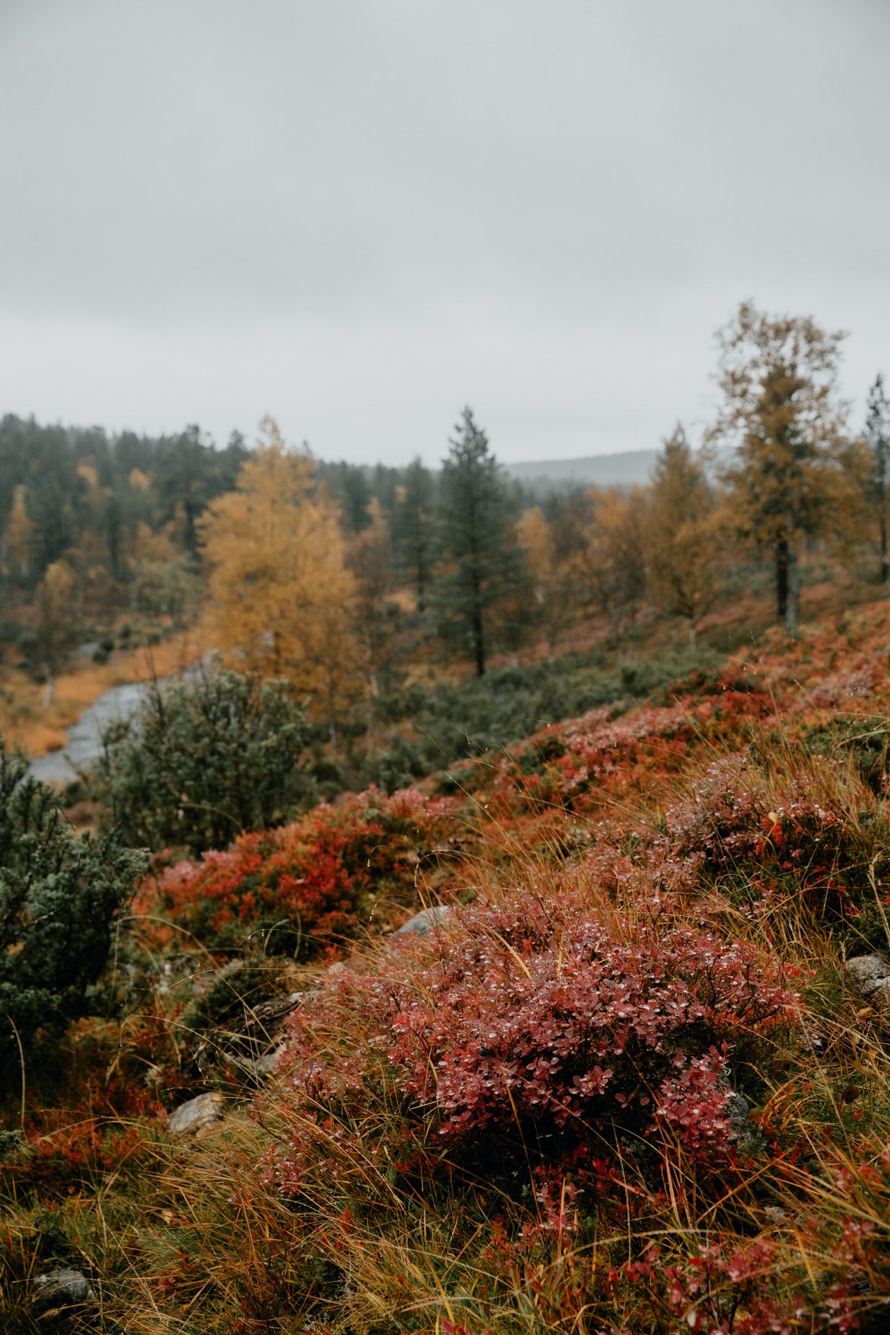
The nature of Hammastunturi wilderness is characterized by barren fell highlands and pine forests. In the southern parts, there are more hill landscapes and mires, in the north there are more fells. The highest fell in the wilderness is Hammastunturi (Pänniordo), 531 meters (1742 ft).
Hammastunturi wilderness area is linked to Lapland's gold mining history from the 19th century. Gold digging sites were, e.g., River Ivalojoki (Kultala), Moberginoja, Pahaoja and Ritakoski. Some of the gold era buildings have been destroyed, some have been restored as a museum.
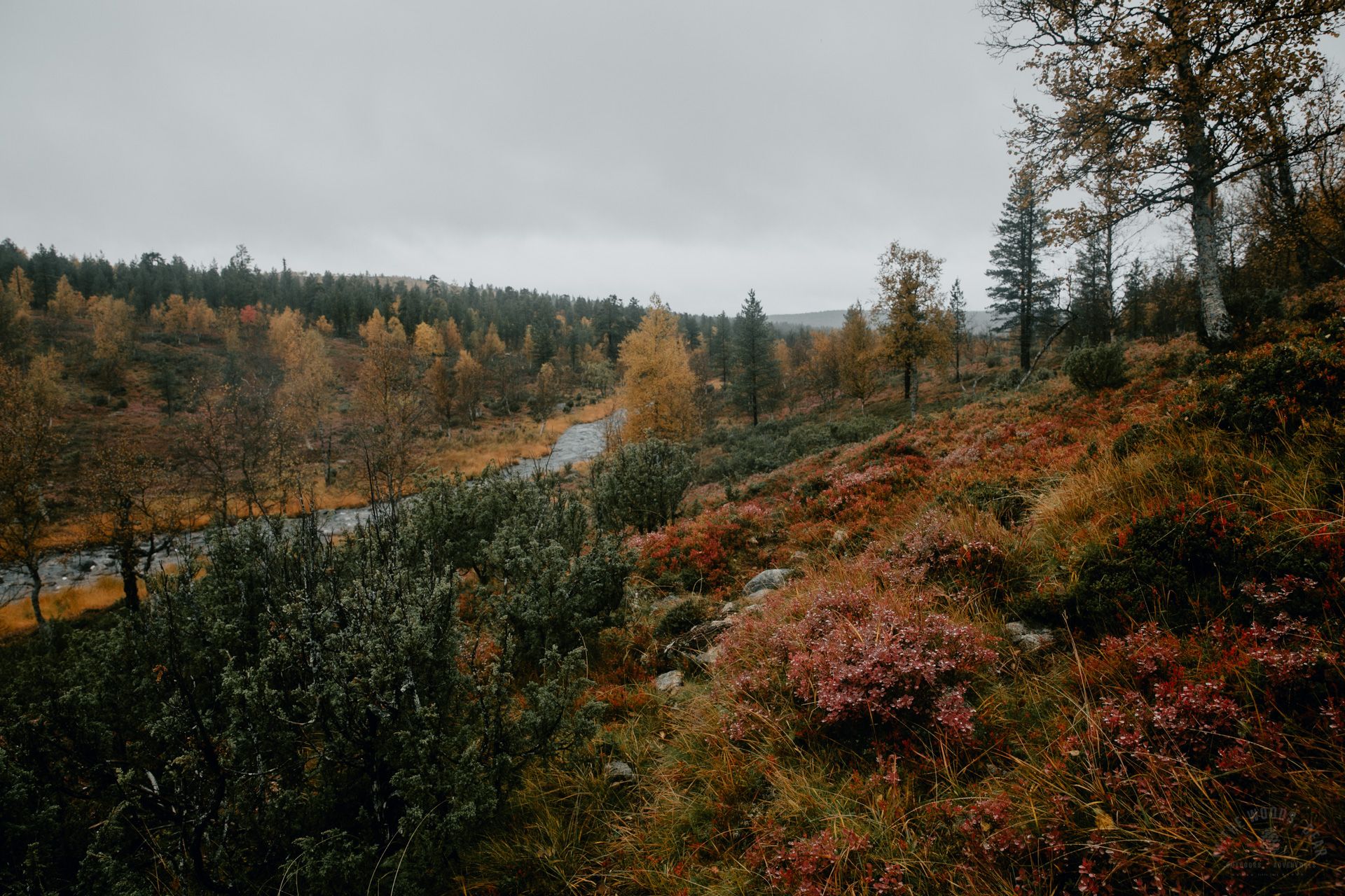
The most famous gold river in Finland, the picturesque River Ivalojoki, flows through Hammastunturi. Ivalojoki is one of Finland's finest and most popular kayaking routes. There are also numerous lakes with clear water in the wilderness area.
Hammastunturi Wilderness – routes
There is only one marked hiking trail in the Hammastunturi wilderness area, the 12-kilometer (7.5 miles) Pahaoja-Ivalojoki Kultala trail. Kilometer posts have been placed along the route, which tell how much distance has been covered and how much is still left. The starting point of the summer hiking route is the Sotajoentie road parking area.
There are many established paths in the wilderness, and most of the time I found a trail exactly where I had drawn a route for myself. The biggest paths are shown on maps and map applications. When you go around the bogs, the terrain is often relatively easy to walk.
Hammastunturi wilderness is a great destination because there are no roads in the wilderness area, and you can really enjoy the peace and quiet of wilderness. If you only have a day trip in mind, you can visit Ivalo's Kultala or Rautujärvi's day hut.


Hammastunturi Wilderness – huts and shelters
There are six open wilderness huts in the Hammastunturi wilderness area. I visited only one of these, the Ivalojoki Kultala open wilderness hut, which also has a reservation hut in the same building. The gold mining history is present on the Ivalojoki Kultala area.
Pahaoja cabin near the parking area is also related to gold mining. The building has served as an open wilderness and reservation hut but is now only a museum. There are several boards in the area about the history of Pahaoja and the gold era.
The Hammastunturi wilderness hut found on older maps is not an official open wilderness hut. The cabin is still in the forest, but there is no dry toilet or wood maintenance.
The Hammastunturi wilderness area also has numerous campfire sites, Lappish huts and lean-to shelters. I visited the nice Rautujärvi day hut. The recently renovated day hut is located in the northeast corner of the wilderness area on the north shore of Lake Rautujärvi.
There are also several rental cabins in the wilderness area. The huts are marked on the map. The map of Hammastunturi can be found on the Retkikartta.fi service.
Hammastunturi Wilderness – fishing
In the lakes of the Hammastunturi wilderness area, angling and ice fishing are free of charge. The fishery maintenance fee is sufficient for lure fishing, except for special waters. For example, Lake Hammasjärvi has a restricted area at the River Kirakkajoki bridge. Special waters and restricted areas should be checked on the kalastusrajoitus.fi map.
Fishing in flowing waters, such as River Ivalojoki, also requires a fishing license. In streams, the fishing restriction period begins in September, which should be taken into account when planning a fall hike. Detailed information can be found on the Eräluvat.fi service.
If your adventures include hiking and fishing, the Hammastunturi wilderness area is a great destination. The landscapes looked a bit like a gentler UKK National Park, but the Hammastunturi hike reminded me quite a lot of my Muotkatunturi wilderness hike.


Hiking adventure in Hammastunturi Wilderness
I left Kiilopää by bus to the Kuttura crossroads stop, where my taxi was already waiting. It took about 20 minutes from the Kuttura crossroads to a summer cafe, chatting with the taxi driver and watching reindeer along the side of the road.
Unfortunately, they had ran out of reindeer burgers in the cafe, so I had to settle for a cheese roll and coffee. I sat on the terrace for a while before starting my hike in the rain – a good 10 km (6.2 miles) of boring dirt road.
After two hours of walking, I stood in the parking lot of Sotajoentie road, where there were a few cars. I found a dry toilet and an information board about the gold history of River Ivalojoki and a map of Hammastunturi wilderness. River Ivalojoki's fishing spots were also marked on the map.
I hiked into the dense coniferous forest to the path that would lead to Ivalojoki’s Kultala and the wilderness. Pahaoja cabin was located 500 meters (1640 ft) away, it was still 11.5 km (7.1 miles) to Kultala. On the marked route, I met four group of people, the next time I saw other people only on the day of departure.
At Pahaoja, I peeked inside the cabin and read the history stories in the yard. I descended down to the suspension bridge of River Sotaoja, after which the path went up to the slope of Pahaojanpalo. The stones were wet and slippery.
After a while I turned to look behind me. Pahaoja hut was only a spot in the middle of the yellow forest. The pine forest became denser, the path sometimes went up and sometimes down gentle slopes. There were small streams across the path, which required no wading.
The kilometers had seemed quick at first, but now the journey seemed to last forever. My clothes started to feel wet from the inside as well. I packed the camera in a dry bag and started walking faster with the warmth of the wilderness hut in mind.
The dark forest changed to an open highland when I reached the intersection where the path to Patatunturi fell started. I was tired and because of the rain and fog, I skipped the additional visit to the peak of Patatunturi.
I descended steeply down to the Pataoja stream, which I could cross with dry feet (or well, my shoes were soaking wet) along the big stones. After the stream, the path first went up steeply towards Patavaara hill and then continued gently uphill in the forest all the way to the top of Patavaara.


River Ivalojoki’s Kultala
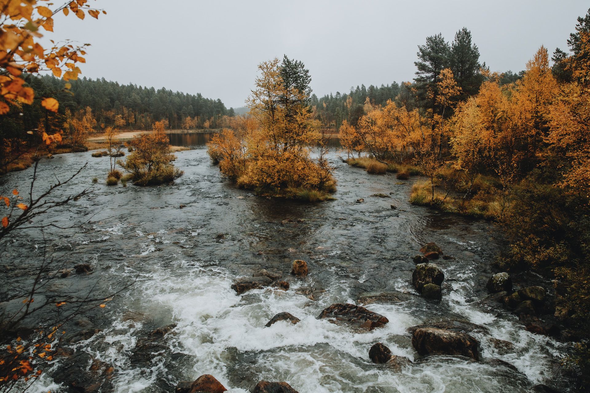
One of the most beautiful and most photographed viewpoints in the Hammastunturi wilderness area is on the slope of Patavaara just before descending to the suspension bridge of River Ivalojoki’s Kultala. Even though it was raining and foggy, I stood for a long time admiring the meandering River Ivalojoki and the wonderful landscape framed by the autumn colors.
The old stairs down to the river had been taken down and the new route was lined up to the right on a steep slope. The path was rough and rocky, the mud slipped underfoot. Even though there were ropes next to the path and I used poles to help, going down was painfully slow.
The journey continued right at the riverbank, on slippery rocks. The suspension bridge looked a little scary in the dark and stormy night with the foamy river roaring below it. I crossed the bridge as fast as I could.
On the opposite side, there was still a short rocky slope to climb. The path first passed a rental cabin, went across a meadow and then passed some other cabin. The open wilderness hut was the last of the buildings seen from the bridge.
The first door belonged to the reservation hut, the latter to the open wilderness hut. I could hear some noise from the reservation side, but the open wilderness hut was empty to my great joy! 23.5 kilometers (14.6 miles) of hiking from Kutturantie road and six hours had passed. I had hiked 33.5 km (20.8 miles) on that day.
As soon as I took my shoes off, I set up fire in the stove and hung every single piece of clothing to dry on the rack above it. I opened a Long Drink can I brought from Kiilopää and decided that I'm definitely not going to the tent for the night.
Although the hut got hot quickly, it was a luxury to sleep indoors when it had already been raining for a couple of days. There were three bunk beds in the cabin. I slept in the middle double bed like a queen.


From Ivalojoki's Kultala to Hammastunturi
In the morning, my clothes and equipment were dry, except for the shoes and one pair of socks which felt a little damp. It was raining outside, so I put some wood in the stove.
I lingered over breakfast and read the guestbook. After that I still had to wait for the wood to burn and the ashes to cool. I didn't get going until 10:30 am.
A path started behind the rental hut, climbing up steeply. The humidity immediately started to creep under my rain clothes. When climbing to the top of the southwest corner of Pietarlauttanen fell, the path gradually disappeared into the landscape.
The misty forest landscapes looked beautiful, even though I couldn't see very far. On the right side remained the bog and Kehäpää when I passed the border of the spruce forest. It was wet everywhere.
I climbed up the slopes of Pietarlauttanen. The visibility was close to zero, so I decided to skip the top of fell and go around it on the east side. At first, I suspected the paths to be reindeer paths, but then I saw a pile of stones. Bear droppings were also occasionally on the ground.
Pietarlauttanen was a little rocky, but it was easy to walk. I went around the bogs by going to Härkävaara hill from the east side of Kivipää. There were several ponds and a nice little waterfall on the lower slopes.
You could easily cross the swamp and stream between Kivipää and Härkävaara. The low vegetation of the slopes on the north side of Härkävaara was great for walking. I climbed to the top rock pile of the hill.
I could see the lakes in the distance where I had thought of going fishing. Due to the rain and wind, I decided to skip the visit to Lake Ahven-Kulvakko and go straight to Hammastunturi fell. To the north of Haukkapää, the slopes became very wet around the spring.


The clouds were hanging low and veiling the Hammastunturi peak. I concluded that there would be no great joy from summitting Pänniordo with poor visibility, so I headed to the west side of the fell to the River Kulvakkojoki valley. I was hoping that the riverbank would be easy to walk.
On the east side of River Kulvakkojoki, there were several paths along the riverbank. I admired the beautiful fall colors and watched the reindeer jogging on the slopes of Hammastunturi. The path would have continued even further in the direction of Lake Aittajärvi, but I decided to turn towards the Hammastunturi wilderness hut.
For some reason, navigation was a bit tricky at this point in the fog and dense forest. There would have been a path to the cabin, but I couldn't find it. It took two hours to hike from the south side of Hammastunturi fell to the wilderness hut through River Kulvakkojoki valley.
Hammastunturi wilderness hut was gray and shabby. There was a broken fireplace in the corner, wide benches on both walls and a table in front of the window. I couldn't get wet wood burning in the stove and water was dripping from the roof.
However, I had some bread and rested my feet. For a while I wondered if I should have stayed in the cabin for the night because of the rain, but I wanted to get to the lake shore for fishing. And Hammastunturi cabin was rather eerie in the middle of a dark forest.
To my delight, the rain stopped as I continued on my way. A good path started from the hut, which led directly to the stream going down to Lake Aittajärvi. The stream was deep, and the water flowed quickly. A skinny tree trunk was put over it, mossy and slippery from the rain. I knew that the surest way to get all my stuff wet was to try crossing the stream by walking on the trunk.
I headed downstream, looking for a place to cross the stream. It didn't take long to find a spot. The stream made a sharp bend, and the shallow spot was before the bend. The water reached my calf, the bottom was fairly smooth small stones.
After changing my shoes, I quickly continued on the trail, because the clock was mercilessly going towards the evening. There were puddles and it was really wet anyway. Finally, I got to the shore of Lake Aittajärvi, where I found dry and flat land.


Camping and fishing at Lake Aittajärvi
I found a nice campfire site on the shore of Lake Aittajärvi. I was already feasting on fresh fish fillet and mashed potatoes in my mind. I quickly set up my tent and went fishing. The wind was strong, but I found a sheltered spot by the shore.
The fish caught quickly! However, I couldn't pull the fish up, it got away at the last moment. Then there were no more fish that evening, and I realized I was already cold and very hungry. A la carte changed to outdoor food bag. I felt the 55 kilometers (34.2 miles) of hiking in the cold rainy weather during the last two days in my bones, and I couldn't do anything but sink into my sleeping bag.
During the night I woke up a couple of times to some strange hussle. At least reindeer had come to leave droppings near the camp, and the howling sound was possibly the howling of wolves. At seven in the morning the rain stopped, so I quickly got up to pack my stuff.
I set up a fire from a couple of dry pieces of wood I was carrying in my backpack. While eating my morning porridge, I smoked socks and shoes instead of a delicious trout. Oh well.


I set off along a trail, the lake remained on my left side. The terrain was really wet, and the wet shoes gradually became soaked. A few hundred meters away was an even nicer campsite by the lake. There would have been a beach with fine sand here.
I arrived at a wide and foggy swamp and fell into melancholy for a moment, as I do on every hiking trip. Then I just stayed there for a while, eating billberries and lingonberries from the bushes.
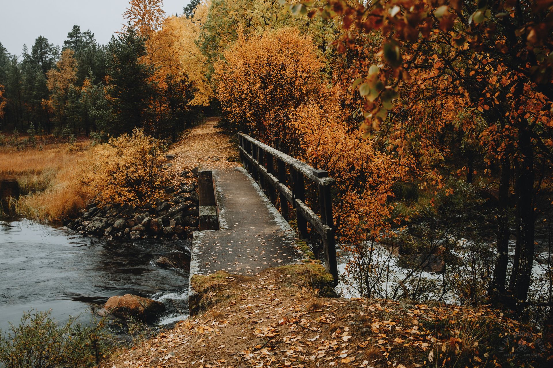
It was four kilometers to the Lake Hammasjärvi bridge. The swamp turned into misty Lake Vuorhajärvi and Lake Vuorhajärvi into narrow Vuorhasalmi inlet. The bridge was decorated with brilliant yellow tree leaves.
Lake Hammasjärvi, fishing and wading in River Kirakkajoki
Kirakkajoki roared like rapids in the middle of the fall colors. Fishing is prohibited in the rapids and the restricted area extends several hundred meters along the shoreline. I walked further towards Sokerilahti bay (Sugar Bay) until I found a point where I could get to the shore of Lake Hammasjärvi. Fishing was fun, but I ended up with no fish in the end.
I returned the same path back to the bridge, crossed the rapids and headed towards the slopes of Lusmamorosto. A visible path was found here as well. It was very wet in places and the path was full of puddles. The billberries were big and juicy, and the fall was beautiful even in the fog.


From Lusmamorosto, the path descended for a long way first to the reindeer fence and gate, and then arrived at the River Kirakkajoki and River Ahvenjoki. There was a river crossing at the River Kirakkajoki bend. Since the wading spot was marked on the bank, I decided it was the best option.
The water was well above my knee, the current was quite strong, and the river bottom was full of different sizes of mossy and slippery stones and mud pockets. If I had known how difficult the wading was, I would have definitely put my cell phone and satellite communication device in the safe. Well, I made it through the wade without falling and learned a new packing routine for future wades.
The path continued on the other side of the river and curved through the forest to Lake Ahvenjärvi. An easy trail went around the lake. Unfortunately, the shore of Lake Ahvenjärvi was shallow and not really suitable for fishing.
Only a short strip of land cut by a stream separated Lake Ahvenjärvi from Lake Rautujärvi. I passed a quiet hammock camp on my way - I hadn't seen any other signs of people since River Ivalojoki’s Kultala. The shores of Lake Rautujärvi also looked very shallow and rocky.


Lake Rautujärvi and the day hut
Lake Rautujärvi's day hut was empty, but the atmospheric hut was still warm from the previous visitor. I went to set up my tent and found a few flat spots in the yard. I put the fires in the stove in the hut and hung my clothes to dry. I ate a very late soup lunch and went to see the fishing spots.
A rather nice fishing spot was found a few hundred meters ahead of the trail. There was no life in the lake, but I was optimistic. For a very short while, as the wind got stronger and it started raining more again, so I quit fishing before the wind caught the lure in my eye.
I looked out the window to the rainy lake. The hut had warmed up like a nice sauna. After all, the rain wouldn't hurt swimming. Next to the hut was a great rocky beach, the water clear and ice cold. A dip in the wilderness lake of Lapland was one of the best moments of the entire adventure.
It was drizzling all evening. I read the guest book and again ate the outdoor food and the last goodies I found in the backpack. At night, wolves howled again.


It was still raining in the morning, what a surprise. I dried the tent inside the hut for a while so that it wouldn't weigh so much. I cleaned the hut nicely, because I was procrastinating leaving in the rain in dry clothes. I couldn’t find an ash container, so I left the ashes in the bucket.
And then to the last stretch. I didn't even get to the tip of the cape when all my clothes were already wet.
I had planned to hike on the last day through Kuppiskuru gorge, and Korkianokka and Siliäselkä fells to Kuppisoja road, but, in the dreary weather I walked straight on the path towards Lake Pasaslompolo. The path leads to a road with a parking lot.
I took a shortcut by crossing the River Taimenoja and walking along a forest truck track in the logging area. There was a big reindeer herd in the forest, which started running around when it noticed me. Then there were only twenty-five kilometers (15.5 miles) of dirt road left in the drizzle.
However, I wanted to stop by to see the scenery at Lake Iso-Kuppisjärvi, which could be reached by road. In the rain and fog, the scenery didn't look any special, and I followed my own tracks back to Kuppisojantie road. A car driver coming from the direction of Lake Rautujärvi offered a ride, but I politely declined, because what could be more fun than walking in the rain.
I had arranged to be picked up by a taxi at one of the intersections of Kuppisojantie road, where I arrived an hour early. While I was waiting, I made dinner at the foot of a big tree, sheltered from the heaviest rain. The evening was already getting dark when the lights of the taxi showed up to take the soaking wet hiker to the airport. After six days of hiking in the rain, you don't feel so bad about going home!


Lapland 2022 autumn hikes
- Luirojärvi hike and Hammastunturi hike
- A total of 203 km (126 miles) and 7 nights (lightweight backpacking is great!)
- Rainy days 6/8 (rain, rain and rain.)
- By the fire 10 times (no rush)
- 8 Wades (only one difficult)
- I caught 3 fish, and 3 fish escaped from the lure (fishing is still fun)
- 1 Swimming in the clear and cold waters of Lapland
- One night in a wilderness hut (huts can be sometimes nice)
- One night in laavu lean-to shelter (awesome!)
- I recommend both destinations!


