Kebnekaise Hike: Climbing Solo the Highest Peak in Sweden
Kebnekaise (Giebmegáisi in Sámi) is Sweden’s highest mountain, its summit reaching 2,097 m. It has two peaks, the southern Sydtoppen and the northern Nordtoppen. Kebnekaise is located in North Sweden around 80 kilometers from Kiruna. It’s a real Swedish classic hike in a high alpine environment.
I hiked Kebnekaise via the western trail in the end of August in 2021. The first snow had just come to the summit the day before. During this adventure my camera was a bit broken, and the clouds and fog blocked most of the sceneries. I hope you’ll get the idea of the trail and hiking Kebnekaise in a cloudy day!
Getting to Kebnekaise
There are basically two ways to get to Kebnekaise: by foot or by helicopter. There’s also a boat available at Lake Láddujávri. Either way, the closest starting point is Nikkaluokta Sarri. From Nikkaluokta it’s around 19 kilometers easy hike to the foot of Kebnekaise. I hiked to Kebnekaise from Nikkaluokta walking the Dag Hammarskjöldsleden trail. The trail is a pilgrim route and the most popular way to Kebnekaise and further to the Kungsleden Trail.
Although the trail is fast, and even if you started walking at sunrise from Nikkaluokta, it takes a bit too much time to make the Kebnekaise hike in the same day. Maybe in the mid-summer, when the sun doesn’t set at all, this could be a tough but wonderful adventure!
Kebnekaise Mountain station
Kebnekaise mountain station is located right at the foot of Kebnekaise. The station’s facilities include accommodation, restaurant, shop and other facilities. Camping near the fell station costs 250 SEK (members) and 350 SEK (non-members). That includes facilities such as using the fell station’s kitchen, showers and drying room.
Camping near Kebnekaise is free, if you don’t need any facilities. Just before reaching the Kebnekaise Fjällstation there’s a popular small forestry area with great tent spots. If you don’t like other people and tents being just a couple of meters from your tent, keep walking.
The Kebnekaise hike can also be combined with a trip to the magical glacier valley of Tarfala. The distance from the Dag Hammarskjöldsleden to Tarfala from the Darfaljohka bridge is approximately 6 kilometers, and from Kebnekaise mountain station, 8 kilometers.
Right after the fell station the trail ascends a bit, and you arrive to a beautiful spot with a view down to the valley. There are great tenting spots as well and you can find some privacy too. The wind can be really strong on this side, so use the ready-made stone walls or collect rocks around your tent and for securing the cords.
When I arrived at the site, it was not at all crowded and I got to choose a perfect place with a view and a big stone that served as my kitchen and sofa.


The main routes to Kebnekaise
There are two main routes to Kebnekaise: the western and the eastern route. The eastern route contains a via ferrata and requires glacier passing as well as special climbing equipment. There are guided tours by STF. It is possible to take the eastern route without a guide at one’s own risk, but it is not recommended.
The western route (Västra Leden) to Kebnekaise is a trail for everyone going on their own. The return trip is around 18 kilometers and with 1,800 m elevation gain. The trail is nicely built and it doesn’t require any technical climbing, only some scrambling. I chose the western route because I was hiking solo. Not that I’ve got any glacier experience either.
The trail is marked with poles painted with red. Sometimes the markings can be difficult to detect, especially in poor weather conditions. Most of the trail runs in a high alpine terrain and it is exposed to winds and rapidly changing weather.
It is possible to get lost on the trip to Kebnekaise – this happened to some group of people the same day I was in the mountain. Although the Kebnekaise hike is relatively easy and basic fitness is enough, sometimes accidents and emergency situations happen, particularly due to the challenging weather. It’s important to have warm and dry clothes as well as some extra energy in your pockets.


The hike to Kebnekaise summit: the western route
I woke up at 8 AM to be on my way to the mountain early in the morning. The sky was still grey and covered with low clouds, a bit dripping too. I had checked the weather forecast for Kebnekaise summit, and it was OK to go summitting the mountain that day. Not particularly nice weather, but doable. I was a bit upset that my camera was somewhat broken after my wet Halti adventure, but you’ve got to accept things that you can’t change.
The trail head was easy to find, as it was marked with a signpost at the crossroads, with a big ‘Västra Leden’ sign and with a pile of rocks. And with a reindeer.
For the first couple of kilometers the trail was narrow with wet willows on both sides. Soon the trail came to a stream that required crossing by stepping on the rocks. I got my hiking boots a bit wet here as there was quite a lot of water in the stream. This was the only stream on the whole trip where you could get your boots wet.
Then the slope got a bit steeper as the trail turned to Kittelbäcken (Giebmejohka). The trail runs around a kilometer high above the river and becomes very rocky and very slippery when wet. All the wider streams had some stone bridges over and the narrower streams were easily passed by. The visibility was poor, not a sight of the huge mountains, just fog and moist. I met a couple of trail runners on my way up. Quite a weather to trail run Kebnekaise. Well, quite a weather to hike it.
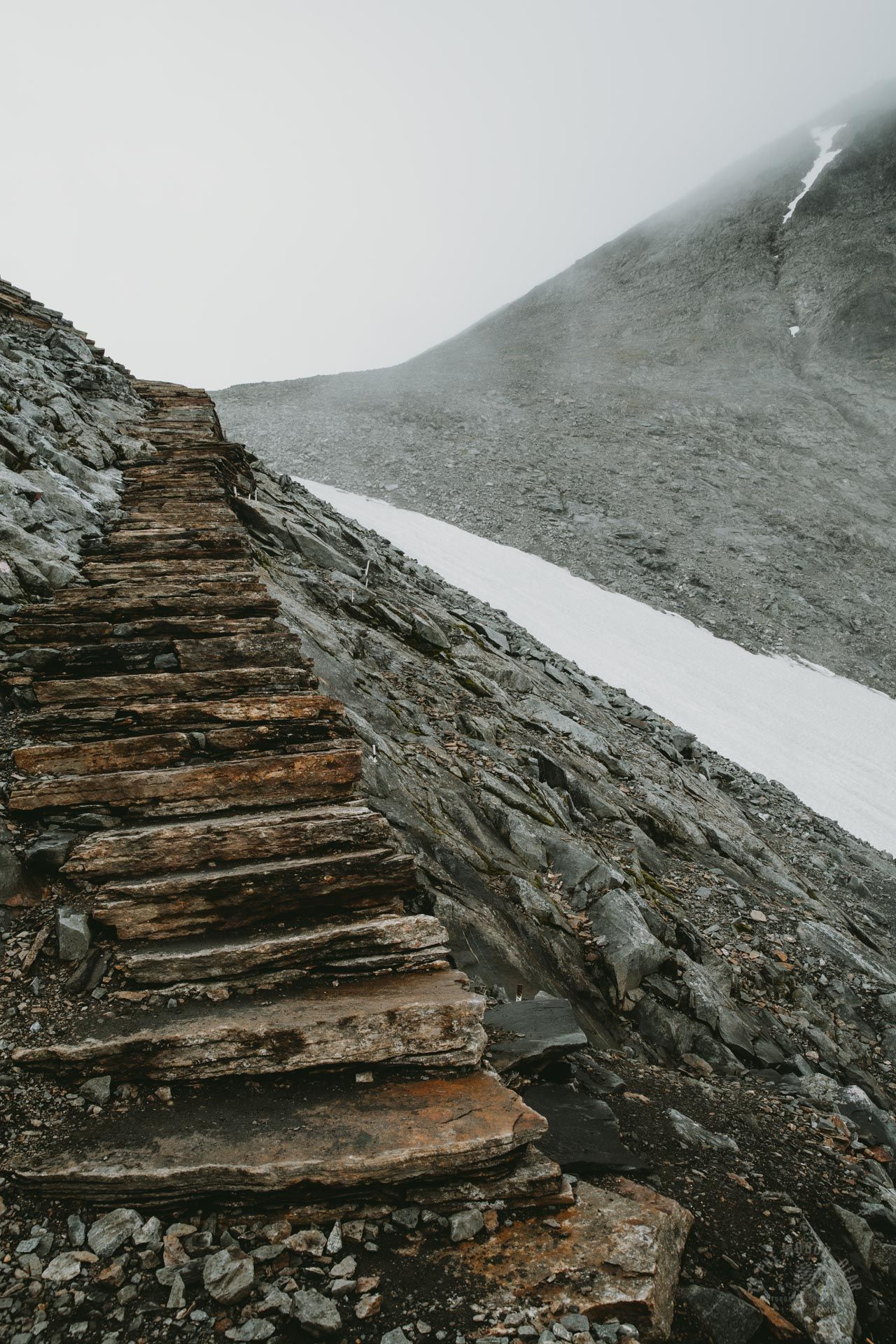
After the Kittelbäcken stretch the trail turned to a bridge over the river. Between Tolpagorni and Vierranvárri the slope is built with beautiful stone stairs that take you all the way up to the saddle between the mountains. The low clouds were suddenly fading, and I got glimpses of Kebnetjåkka and Kebnekaise. I was standing on the saddle and gazing at the whirling clouds below me. The mountains felt so huge!
I met a guy from UK, and we chatted about the weather and hiking routes. He was navigating with a GPS watch and he contemplated if he should return the same way because of the clouds or go down to the valley the other side. I recommended sticking to the marked route and started climbing the mountain.
Before Kebnekaise, you actually summit a smaller mountain, Vierranvárri (1716 m). Then you need to descend the smaller mountain. And when you return from Kebnekaise, you’ll climb up and down the smaller mountain again. This stretch of the trail is the most technical part of the whole trip.
The trail was steeper than earlier, and the loose rocks and gravel made climbing a bit tough but not too difficult. When I reached the summit, I saw it was full of small piles of rocks that visitors had built. The sight felt a bit creepy and annoying at the same time.
Suddenly, a lot of people seemed to appear from nowhere, all coming from the summit. I saw many people without any backpacks, and some had even sneakers. They just looked like they were on a quite ordinary Sunday walk. Okay, maybe I was a late bird once again, but I still wasn’t sure about the sneakers.


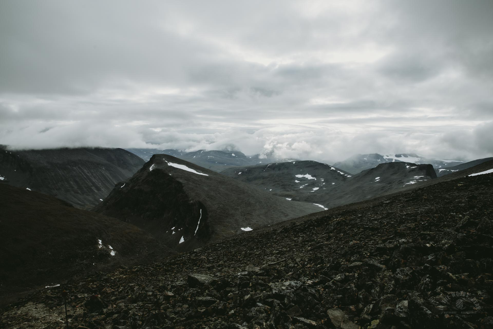
When you get down to the saddle between Vierranvárri and Kebnekaise, you’ll see a beautiful scenery to both directions. If there are no clouds. Luckily, low clouds and fog were gone, there were almost blue spots in the sky, and the sun was shining behind the clouds. I was so excited to see the amazing views from the Kebnekaise summit after all!
By the time I started climbing the last slope towards the summit, the crowds had disappeared. First, I saw two men coming down from the summit, they were the last ones before me. Then, I saw a backpack and a mug lying on the rocks. I wondered what ever happened to the owner, as I was the only one in the mountain.
Looking to the East and South the views were so peaceful. There were short moments of light, but the clouds were returning fast. I climbed faster. Just before the first hut it started snowing and the sky was again completely covered with clouds. I sighed and continued. The time difference between visibility and no visibility at the hut was five minutes. Then it took 25 minutes to reach the upper hut, Toppstugan.
It was dark, a few crows shrieked in the fog. I saw a bigger pile of rocks and an old frozen milk container. Maybe the summit mark was here on the rocks, as the summit top is covered with snow. It was 6 PM, the hike to Kebnekaise lasted seven hours. I looked towards the top to climb it but couldn’t see anything. When I tried my best, I could spot the edge of snow in the whiteness and footprints on the snow.
It was a brief moment of disappointment. I pondered whether I should climb the last steps to the summit. I wouldn’t be able to see anything from the top. It would be difficult to tell where the snow ended, and the clouds started. I could make a mistake and step into air or slide. I didn’t want to end up to Björlings glacier and I made the decision to turn back from the snow. I started descending in grey silence, just the sounds of the birds echoing in the mountain.
I thought I was the last person in the mountain (as usual) but down in the first slope I met a guy who was still going up although it was already quite late, and the weather was getting worse. And it was really dark in the mountains. He had pitched a tent on the saddle, at least the trip was not that long. I climbed Vierranvárri the second time. The Kebnekaise side was probably the most difficult stretch of the whole trail, both up and down.


And I climbed down Vierranvárri. The low clouds had disappeared from this side of Kebnekaise, and I could finally see Björlings glacier and Kebnekaise. The South summit was covered with clouds, but the rest of the mountain stood there like a black giant. The valley of river Kittelbäcken was clear too. On a good day, Tolpaguorni could be a very nice mountain to climb on a Kebnekaise adventure.
I walked in the darkening night. Now there was even more water in the stream than in the morning. Finally, around 10 PM I was back at my tent. The return trip was around four hours and the whole trip took almost 11 hours. After having a warm meal, I crawled into my sleeping bag. The next day was the brightest summer day ever. I looked at Kebnekaise on my way to the King’s Trail. It was bathing in sunlight against a deep blue sky.


