Kilpisjärvi-Halti Trail 2/2: Rain, Fog and Endless Boulders
Halti is the highest fell in Finland with the peak, Háldičohkka, at 1324 m above the sea level. The trail to Halti from Kilpisjärvi, the Arctic Trail or Nordkalott Trail, is the most popular route to Halti from Finland, but several unmarked routes through wilderness lead to Halti as well. I chose the Nordkalott route on my way to Halti but hiked back to Kilpisjärvi via Termisjärvi, following the Arctic Trail to the Kuonjarjoki hut before taking my own path.
It’s not necessarily boring to go back the same trail when it’s not a ring route or you need to get back to the starting point for some reason. On your way back, you see different things from another perspective. Especially, if the weather changes, it’s a whole new experience. My journey from Kilpisjärvi to Halti, and my journey from Halti to Kilpisjärvi were like day and night. This is the part 2: the story of hiking in rain and fog, scrambling through endless boulders, and learning how important it is to pitch your tent securely.
Goodbye Halti summit
After writing down my name into the guestbook, I began my return journey and started walking down from the Halti summit. Most of the views were covered by thick white clouds. The dripping was turning into raining. Getting down was easy and fast, but I didn’t have the urge to run anymore. I was in my own thoughts most of the time while hiking the trail from the summit to the Pihtsusjärvi hut.
Obviously, the Pihtsusjärvi hut was full of people seeking shelter from the rain. My trail running shoes were wet and hiking tights moist. My gloves were wet and my hands freezing cold. I was hungry. I broke the hut rules and used my stove on the terrace and made hot blueberry soup with a chocolate bar while I was sitting on a bench under the roof. It would have been nice to stay and sit by the warm fireplace. But my tent was waiting at Meekonjärvi. Back to the rain, only 11 km to go!


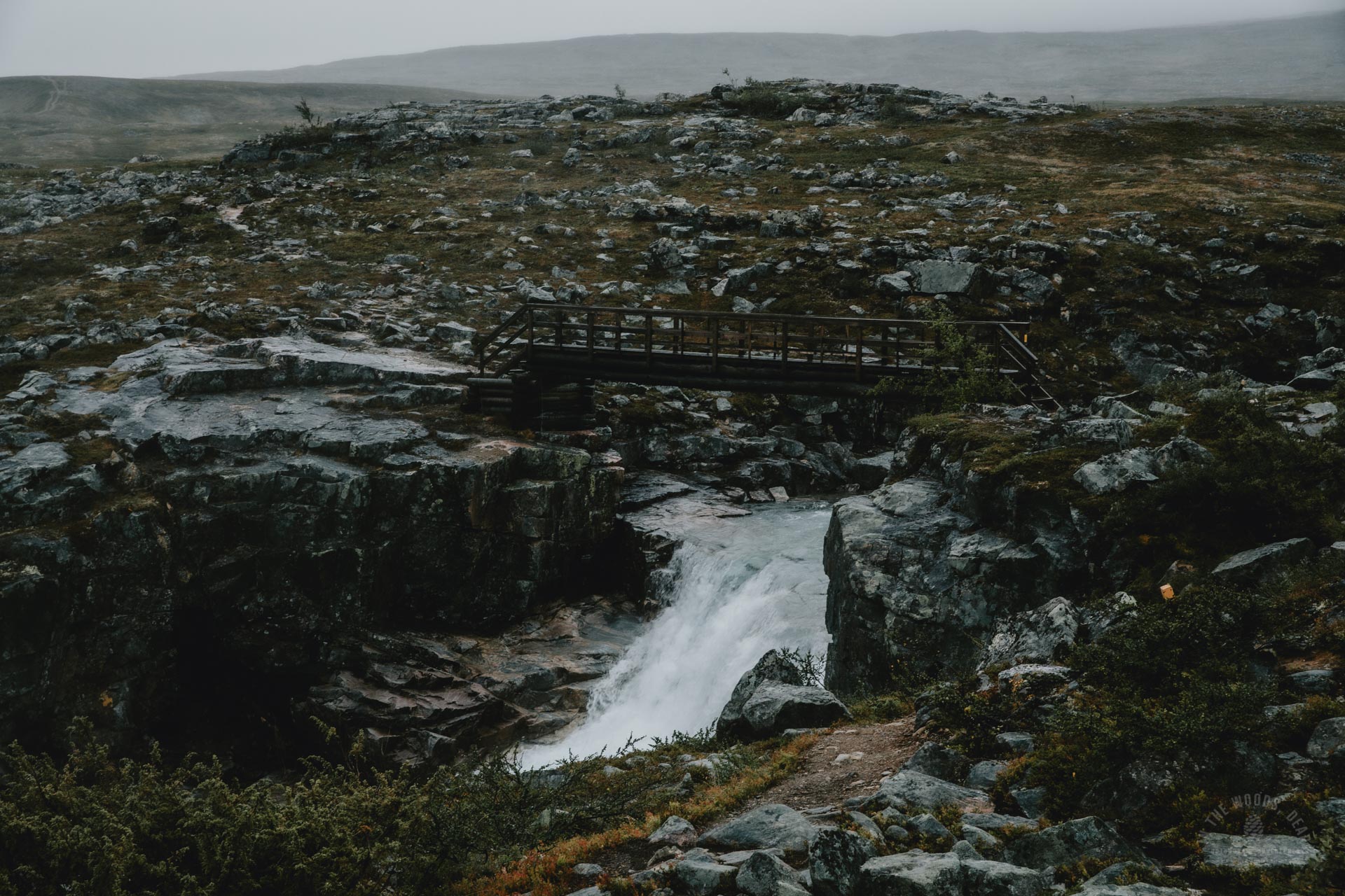
A wet journey from Pihtsusjärvi to Meekonjärvi
All the rocks were slippery in the rain and moving forward got slower. The trail had become wet, and puddles were getting bigger. The bushes and willows on both sides of the trail were wet too, and soon my shoes, socks and tights were soaking wet. I arrived at Pihtsusköngäs waterfall. I had to take a short break to watch the beautiful white cascade roaring against black rock.
Since the bridge of River Vuomakasjoki had been broken by the spring flood, crossing the river by wading or hopping on the rocks was waiting again. I had thought of wading across the Lake Vuomakasjärvi at the shallow northern corner, but somehow going back to the same and familiar rock-hopping route that I had used in the morning sounded more tempting in the rain. I was a bit nervous if the water level had already risen because of the rain, as the wading place was at least 150 meters wide and crossing the river had been described as challenging. I was relieved after finding rocks under my every step (some had a few centimeters of water above them) and getting safely to the other side.
But for a while, I had been having weird feelings about something not being right. The closer I came to Meekonjärvi, the more I felt that something was wrong with my tent. The boulders at the Lake Meekonjärvi shore were very slippery, slow and frustrating.
I saw it already from a far. My orange tent looked different, somehow like smaller. I scrambled forward as quickly as I could. Then I realized the tent wasn’t smaller, it was upside down! How could it be? The six pegs were deep in the ground, the spot was not particularly exposed to winds, and the wind was not that hard in the first place! My first thought was that my stuff had been stolen and the empty tent had been light enough to fly away with the wind. My heart was beating fast when I run the last meters to my tent.
I tried to lift the other edge of the tent to get it up, but it was heavy. I opened the zipper a bit and saw that everything was there, my sleeping bag and pad, clothes, backpack. My hiking boots and socks, a picnic tarp and a water bottle that had been in the vestibule were on a rack against the wall of a rental hut nearby. Then people from one of the rental huts came to help moving the tent to a new flat spot. They had been worrying and trying to figure out what had happened to the tent owner.
The tent had been in a pond upside down (there was one small pond on the whole hillside area, around 10 m away from my tent – come on, what’s the probability to end up there?!) and the rent hut folks said that I could bring all my wet stuff to their hut but also come to get dry myself. And if that wasn’t enough, they offered a place to spend the night playing cards with them in their warm and cozy hut as well. I was very grateful for the generous offer and brought my soaked boots and socks into the hut, but since my other stuff was not wet at all, I was happy to sleep at my own tiny home.
When I returned to my tent, dried the few small spots of water and put my running clothes hanging around into the gear loft, I got all emotional. That there’s so much goodness and empathy in people. (Lessons learned: always pitch your tent securely and prepared for storm even if the weather forecast said sunshine!)
I was extremely happy for taking my 4-season waterproof tent for this trip, as it really saved me from a lot of agony. Only now, I realized that the wind was really blowing hard at Meekonjärvi as it banged my tent from two sides. But now it was securely attached to the ground with additional cords I found from my just-in-case-stuff pouch, and I slept like a log. After all, it had been a marathon day, 42 km of adventure running.
In the morning I went collecting my hiking boots and socks from the hut and apologized again for all the trouble. People were still very nice and wished me a good hike back to Kilpisjärvi. Back at my tent I got a bit emotional again, sigh.


Hiking in the rain from Meekonjärvi to Kuonjarjoki
After packing my stuff during a short break between rain and more rain I was on my way to Kilpisjärvi. Or that was my plan before the rain: walk to the Lake Tsahkaljärvi and use only three days for the whole Halti journey. At this point I still thought I could make it. I had originally planned to go back to Kilpisjärvi via a longer stretch off the Arctic Trail and see Kutturankuru gorge, but because of limited time I decided to leave the trail at Kuonjarjoki and walk through Salmikuru gorge to the Lake Termisjärvi instead, and from there back to Kilpisjärvi.
I crossed the bridge over River Bierfejohka. The white foam and deep emerald water looked more dramatic in the rain. Yeah, there was also Saivaara fell on my left side – didn’t go there on my way to Halti, not going there today either. I wiped the rain drops from my cheek and continued walking.
If the stretch of the trail from Kuonjarjoki to Meekonjärvi had felt pleasant, maybe the fact that it’s more descending from that direction had something to do with it. Now it was straight up, and quite a long ascending too. I made the same mistakes that I did last time: I forgot to fill my water bottle as there were much less streams than what was marked on my map app. I took water from a quite small and mossy stream, at least it was coming from the fells above and I didn’t spot any dead reindeers.
The middle part of this leg is quite smooth with just mild ascending and descending, and the trail is easy to walk. I sat on a rock for a while and saw a couple of people down by River Kahperusjoki (Gahperusjohka). I was trying to figure out what they were doing as they were walking around and not just crossing the river. When I got closer, I saw they were changing their shoes. A quick look at the river, and I could tell immediately that there was much more water than two days ago. Most of the rocks from the surface were gone and the river fast-flowing.
I felt lazy and walked upstream to find a spot where I could cross the river without taking my boots off. There wasn’t any, quite the opposite. I went back and stood there looking at the river. I was wet(ish) already, and if I sat down and took my boots off in the rain, they would just become more wet. What the heck, just go! During this trip I started to say ‘yasss’ quite often. It was a cheer-me-up statement to myself every time I didn’t want to do something or go somewhere but I just had to. Yasss! And across the river with my hiking boots on. Surprisingly not that wet experience. I can imagine that River Kahperusjoki can be a tad scary when the water is really high, and the river is flooding all over the place.
I came to the Kuonjarjoki hut. A woman was washing dishes on the terrace. After a very brief chat I found out that I’m a wilderness legend. A mystery hiker whose tent was upside down in a pond and who was possibly disappeared to the fells. The woman and her hiking friends had been collecting my stuff in the rain. It was the top news in the hut. (Oh noooo.) I was apologizing again for creating trouble and making people worry. From my point of view the episode was not as dramatic as it obviously looked like to other hikers who had seen the tent gone wild. Embarrassing? Yes!
The bad weather had really pushed people to the huts. The Kuonjarjoki hut is suitable for 10 persons (and restricted to 4 during the covid!), but last night there were 23 people sleeping in the hut. Now it was full of people having their lunch or breakfast and drying their stuff, so I decided to dry mine at Termisjärvi later and just had my soup while my boots and coat were drying near the hut’s stove.
Some people were pondering if they should skip their plans of going to Termisjärvi because of the weather – you wouldn’t see any nice views anyway and navigating the unmarked route would be difficult in a fog. I almost skipped the idea as well, but then I remembered how small the Saarijärvi hut was and that it was possibly too full to even dry my stuff because quite many of the hikers were going there. I had to dry my clothes because I was continuing my hiking journey the next day to a place without any drying facilities. If the weather got any worse, going to Termisjärvi would be a very challenging hike. On the other hand, the probability of extremely bad weather was not that high. The optimistic me won, and I headed down to the river.


A long hike from Kuonjarjoki to Termisjärvi
River Kuonjarjoki can be easily crossed when you walk enough to the left from the trail that comes down straight from the hut. The path that goes straight from the hut to the river is a path to take water, the river is quite deep there for wading. But continuing left, there’s an almost visible path to a wider but rocky spot of the river.
Right after crossing the river (almost with dry boots) the terrain turned into a mixture of boulders and small streams going across the whole ascending field. It’s not too bad if you look the optimal way to go already from a far, and the streams are either small enough to jump over or there are rocks you can use as steps. Siedjonvarri was on my left side and Guonjarvarri on my right – both mostly covered with clouds.
I was prepared for a sweaty scrambling as the map promised large boulder fields. It was not bad at all. The rocks were quite small and there were spots of grass and solid ground here and there. The route to Viittakuru was quite fast actually. But the rain was getting heavier and the wind stronger. I put a small plastic bag on my camera to cover it from the rain. I thought my camera would be in a better place in a drybag in the backpack, but then I couldn’t take any pics. (After this gig I have taken care of my Canon better!)
Viittakuru was very rocky, rocks after rocks as far as you could see (which was not very far in the fog but anyway…). After climbing some easy slopes, the rocky terrain turned into easy boggy field, ending at a vast wetland in the south. At some point, I noticed that my camera lens cover had disappeared. I tried to walk back where I came from, but it was impossible without a visible trail, as everything looked the same. I gave up and continued forward (sorry for leaving plastic items to nature!).
When I reached the wetland, I noticed that it was like a lake. I passed by the wetland from the east side, there was nothing to see at Naalivaara fell in the fog anyway. Based on the map app, I had thought that the shores of the Lake Bahtasgohpejávri were mostly open ground with some rocks here and there, and in one of my hiking plan versions I had marked it as a tenting spot. Well, no. The whole shoreline was just a huge boulder field, with some spots of wet bog. But at least I found a lot of cloudberries while hiking slowly. After the lake, there was an easy stretch, marked as a boulder field gorge, but in reality, it was mostly open ground, and the rocks were small.


The endless horrors of Salmikuru gorge
At the northern end of Salmikuru gorge there is a lake, and a stream going down all the way through the gorge from the small lake to the Lake Termisjärvi. I had thought to cross the river already straight at the upstream to get to the other side of the gorge where there is a marked path later, but it turned out to be impossible. The stream was too wide and deep, and the current was strong. I had tried to look at the satellite map to plan the route, but it had not helped much. So, I decided to go down and walk next to the stream on the east side until reaching the wading spot, which, on the map, seemed to be quite close, just at the trail head. It was a huge mistake.
The slippery wet boulders got bigger and bigger. My backpack got stuck between rocks. A dense willow bush tried to trip me. I hit my leg (exactly the injured spot I had tried to protect the whole journey!) to a sharp rock edge and it started bleeding under the bandaid. I noticed that the plastic bag covering my camera was gone with the wind (sorry for littering nature again!) and the camera was getting wet. While trying to keep a Spider-man balance between the huge rocks it felt too difficult to take the backpack off to put the camera away. I got to a point where I just couldn’t move forward as the boulders were much bigger than me. The only way was to turn back… or up!
Turning back didn’t sound or look tempting as I really wanted to get out of the gorge before dark. Opening the phone got difficult, fingerprint and face recognition didn’t work and trying to tap the wet screen with wet and wrinkled fingers was frustrating. I looked my map to see how far the wading spot was. Considering the boulder slope, far. I started climbing up the steep wall, one step, push and pull at a time.
Walking above the boulder slope was much easier, and I was quickly near the trail head. Getting back down to the river was scrambling the boulder field again, but here it was not even nearly as difficult as before. I finally found the wading place and crossed the stream where there was maybe 20-30 cm of water but a strong current. I also found the trail and I was thrilled – now it was just a brisk walk to the hut. Wrong again. The trail soon disappeared to yet another boulder field, that covered basically the whole gorge. Sometimes there were minor traces which I interpreted as a trail, but mostly it was just endless slippery scrambling. I tried to take a picture of the boulder field of horrors, but the camera started giving error messages. I wiped the camera and put it finally away into a drybag.
I thought I had been scrambling for so long that I had to be near Termisjärvi already. How wrong again. I had been progressing extremely slowly. At this very moment I felt panic, maybe for half a second. Then I said to myself: one step at a time. You will continue until you reach the Termisjärvi hut, because you have to. And so, I continued scrambling one step at a time, on the nonexistent trail, crossing the stream yet a couple of times in the ever-increasing rain and howling wind and darkening night.
At last, the boulder field turned into open ground, the trail was visible and when I got up a small hill, I finally saw the hut by the lake. At least I made it before 10 PM. I was so very grateful for surviving the endless horrors of Salmikuru gorge. (They even came to my nightmares a couple of weeks later!) The hike from Meekonjärvi to Kuonjarjoki had been 10.33 km and it took 3 hours 43 mins. The hike from Kuonjarjoki to Termisjärvi had been one kilometer longer, 11.43 km and it took 6 hours 24 mins. That’s all I’m saying.
There were already 9 people at the 8-person hut, most of them already in their sleeping bags. I apologized once again for arriving so late and disturbing everyone’s sleep. But people were extremely friendly, making room for me to the bench in front of the stove, and making room for my clothes to the hanging cords above. I was offered a bunk, but I said I didn’t mind sleeping on the floor despite of the mice. One adventurous person pitched a tent outside in the rain, although I think there was enough room for at least 12 persons.
I took apart my camera to let it dry near the stove and put all my wet stuff hanging to the cords. I changed my clothes and made warm food and hot chocolate before going to sleep. I can’t really sleep in the open wilderness huts if there are other people, as I keep listening to the sounds and the hut is usually too hot. This night was no exception.


Last leg of the journey from Termisjärvi to Kilpisjärvi
I was up early. I made some oatmeal and coffee and packed my stuff. Everything except my hiking boots and some parts of the tent had dried during the night. I took my camera back together and it seemed to work just fine. Except it didn’t. The manual controls didn’t work at all, but auto mode was ok. I grieved for a while. It was going to be an expensive repair and I had still many days of adventures ahead in Sweden, including Kebnekaise hike. I left the hut at 9 AM.
The trail from Termisjärvi to the Lake Tsahkaljärvi and to Kilpisjärvi is an easy stretch without much ascending or descending. There are some wetland and boggy areas where you get your boots a bit wet. And more wet if you don’t take them off while crossing one river near the Lake Paihkasjärvi in the middle of the stretch. I took some pics, and suddenly noticed that one manual control was back functioning! And then another! My camera wasn’t broken after all! I sat down on a rock and cried a little (a lot of crying during this journey, haha). Then I tried to take a picture of me sitting on the rock, but the remote wasn’t working. Ok, not completely intact but fair enough.
Near the Lake Tsahkaljärvi I didn’t pay much attention to the trail since I had already walked it three days ago. At night with a headlamp. I ended up to the trail that leads to River Tsahkaljoki and the lean-to shelter by the lake. Oh well, at least there were loads of bilberries along the trail! The morning hike was 16.24 km, and it took 4 hours 41 mins.
I drove straight to Kilpisjärvi Holiday Village & Camping to have a lunch, take a hot shower and charge the batteries. I had asked about the shower in advance, and as it wasn’t a peak season at the camping site, I could buy the shower facilities for 6 euros. I had a vegetarian halloumi burger with coke and coffee in the restaurant. Great food, nice service!
Then I jumped into my car, spread my shoes, clothes, and sleeping bag all over the seats and floor, and put the air conditioning and heat to the max. Sweaty hours of driving to Nikkaluokta in Sweden, but worked wonders. I was grateful and happy. And headed to new adventures with lots of new experience and dry stuff!


