Adventures // 8 February 2026
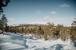
Saariselkä in Lapland, Finland is an amazing winter destination for outdoor lovers. From the top of the highest fell Sokosti, you can enjoy incredible views of Lake Luirojärvi and the white fells of Urho Kekkonen National Park. The varied wilderness and one of Finland's densest networks of open wilderness huts make the area very popular for year-round hiking adventures.
I did a six-day backcountry skiing tour to Sokosti fell and Lake Luirojärvi in Urho Kekkonen National Park in March. I skied about 100 km / 62 miles, with an elevation gain of 2022 m / 6634 ft. The frosts were severe, often exceeding -30°C (-22°F) degrees at night.
Read more
Saariselkä / Lake Luirojärvi & Sokosti Ski Tour
- Destination: Saariselkä/Kiilopää, Urho Kekkonen National Park, Lapland, Finland
- Length: 80 km / 50 miles (normal route, longer routes possible) + 12 km (7.5 miles) Sokosti tour
- Difficulty level: demanding (long-distance winter hiking, unmarked wilderness routes)
- When to go: from December to April (cross-country trails from February; year-round destination)
- Duration: 5-9 days
Destinations // 12 January 2026
The Lampivaara Amethyst Mine winter trail invites you to walk and snowshoe in the snowy old forests of Luosto, Lapland. In the frosts of January and February, the landscape is particularly fairytale-like, with the crown-snow trees painting a beautiful nature scene. In March and April, the deep green of the forest and the rays of the spring sun on the slopes are the best part of the hike.
Along the Lampivaara trail, you climb to the top of Pikku-Luosto fell, with sweeping views of the snowy Ukko-Luosto peak and the surrounding fells in the distance. At Lampivaara, the hike can be completed with a guided visit to an amethyst mine or by stopping for a coffee at the café.
Read more
Lampivaara Amethyst Mine winter trail
- Location: Sodankylä, Central Lapland
- Route length: 5.5 km
- Duration: 1.5-2 h
- Difficulty level: moderate
- When to go: December-April (year-round)
Destinations // 8 January 2026
Ukko-Luosto (514 m) is the highest fell peak in the Luosto area, Lapland, Finland. Located in the Pyhä-Luosto National Park, Ukko-Luosto is accessible in winter for skiing, snowshoeing and walking.
If you are tempted by the white shimmering peak of Ukko-Luosto, this article will give you the route and tips for the hike. In the article you will also find a map of Pyhä-Luosto area, where the Ukko-Luosto route in winter is marked.
Read more
Ukko-Luosto peak, winter trail
- Location: Sodankylä, Central Lapland
- Route length: 3.5 km
- Duration: 1.5-2 h
- Difficulty level: moderate
- When to go: December-April (year-round)
Destinations // 3 January 2026
Tunturiaapa nature trail is located in Pyhä, at the southern part of Pyhä-Luosto National Park. From the vast open mire you'll get great views of the peaks of the Pyhätunturi fells.
The Tunturiaapa nature trail is accessible all year round. In winter, you may admire the beautiful landscape with the northern lights, the dazzling evening sky, frost-covered trees or the bright blue sky against a backdrop of white-peaked fells.
The trail is mostly flat terrain and is quite easy in winter, too. Here's the route description and tips for a 10 km walk or snowshoe hike.
Read more
Tunturiaapa winter trail, Pyhä-Luosto
- Location: Pelkosenniemi and Kemijärvi, Central Lapland
- Route length: 10 km / 6.2 miles
- Duration: 2-3 h
- Difficulty level: easy (long steep stairs)
- When to go: December-April (year-round)
Adventures // 14 August 2025
The Arctic Trail is a demanding 800-kilometre hiking trail along the borders of northern Finland, Norway and Sweden. You don't have to hike the entire Arctic Trail in one go, but can do it in many different sections.
Read more
Arctic Trail, Kopmajoki - Reisadalen
- Destination: Käsivarsi, Lapland, Finland & Saraelv, Reisa, Norway
- Distance: 46 km (one direction, Kopmajoki-Sieimma)
- Difficulty: advanced, trail may be poorly marked, river crossings
- When to go: from end of June to end of September for a summer and autumn hike
- Duration: 2-3 days
- Where to stay: camping in tent, wilderness huts, rental huts
Destinations // 8 July 2025
The Alta Canyon (Sautso) in Finnmark, northern Norway, is the most spectacular hike in Alta region. It is one of the largest canyons in northern Europe, and it can be reached by hiking, cycling and by boat along the river. The canyon hike, south of Alta, is a day trip and not as inaccessible as you might think.
Read more
Alta Canyon
Location: Alta, Finnmark County, Norway
Route length: 12.6 km / 7.8 miles (from Gargia upper parking / trailhead and back)
Difficulty: easy (viewpoint moderate)
Duration: 3-4 h
When to go: from June to September (accessible in winter)
Special: The largest canyon in Northern Europe
Lille Raipas is a well-known fell in Alta, Norway. It is part of the Struve Geodetic Arc and is a UNESCO World Heritage Site. Lille Raipas is a fast route, and the summit offers spectacular views of the Alta fjord.
Read more
Lille Raipas (UNESCO)
Location: Alta, Finnmark County, Norway
Route length: 5.2 km / 3.2 miles (225 m ascent)
Difficulty: easy-moderate
Duration: 45 min - 1h (trail running) / 1.5-2 h (hiking)
When to go: from May to September
Special: UNESCO World Heritage Site, Struve Geodetic Arc
Destinations // 23 June 2025
Kukastunturi (477 m) is one of the easiest routes in Ylläs Lapland to the top of fells. Located in Pallas-Yllästunturi National Park in Finland, the Kukastunturi summit offers great views in all directions. The most convenient way to hike Kukastunturi is from Karila.
Read more
Kukastunturi, Ylläs Trails
- Destination: Muonio, Lapland, Finland
- Distance: 9 km (5.5 miles) / 20 km (12.5 miles)
- Difficulty level: Easy / Medium
- Duration: 2-3 h / 6h (hiking)
- Special: biking route + hiking trail
Destinations // 16 June 2025
Särkitunturi (492 m) is a fell in Muonio Lapland, on the shore of Lake Särkijärvi, overlooking one of the most photographed landscapes in Finland. The Särkitunturi trail is 3 km long in one direction. The highlights of Särkitunturi are the Lappish hut next to a pond and beautiful views of the Pallas-Yllästunturi National Park, rolling fells and lakes.
I have been to Särkitunturi fell four times in the last four years: trail running in summer, hiking in autumn and hiking and snowshoeing in winter. I have wanted to understand the secret of Särkitunturi's popularity - why is Särkitunturi the most visited fell in Muonio?
Read more
Särkitunturi Hike in Muonio
- Destination: Muonio, Lapland, Finland
- Distance: 3 km (one direction)
- Difficulty level: Easy
- Duration: 2 h (whole trip)
Adventures // 10 March 2025
The ski hike to Halti from Kilpisjärvi in Käsivarsi wilderness in Lapland is a winter hiking classic. In winter, you can reach the top of Halti by skiing the Arctic Trail (Nordkalott Trail), or your own trails in Käsivarsi wilderness.
Halti is Finland's highest fell, or Finland's highest point at least. Háldičohkka peak rises to 1324 metres above sea level on the Finnish side, with a few metres higher point on the Norwegian side. The summit of Halti is a popular destination for both summer hiking and winter skiing.
I did a solo ski hike in the Käsivarsi wilderness at the end of March. I had planned a ski tour to Saariselkä and Urho Kekkonen National Park in Lapland, but changed the destination about a week before departure due to the stomach flu epidemic in the UKK Park. So the Sokosti summit was replaced by the conquest of Halti.
Read more
Ski hike Kilpisjärvi - Halti, The Nordkalott Trail
- Destination: Kilpisjärvi and Käsivarsi Wilderness, Lapland, Finland
- Distance: 55 km (one direction)
- Difficulty: advanced, but suitable for beginners (The Nordkalott Trail)
- When to go: from February to April for spring ski tour
- Duration: 5-10 days
- Where to stay: camping in tent, wilderness huts, or rental huts