Adventures // 8 February 2026
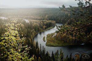
Saariselkä in Lapland, Finland is an amazing winter destination for outdoor lovers. From the top of the highest fell Sokosti, you can enjoy incredible views of Lake Luirojärvi and the white fells of Urho Kekkonen National Park. The varied wilderness and one of Finland's densest networks of open wilderness huts make the area very popular for year-round hiking adventures.
I did a six-day backcountry skiing tour to Sokosti fell and Lake Luirojärvi in Urho Kekkonen National Park in March. I skied about 100 km / 62 miles, with an elevation gain of 2022 m / 6634 ft. The frosts were severe, often exceeding -30°C (-22°F) degrees at night.
Read more
Saariselkä / Lake Luirojärvi & Sokosti Ski Tour
- Destination: Saariselkä/Kiilopää, Urho Kekkonen National Park, Lapland, Finland
- Length: 80 km / 50 miles (normal route, longer routes possible) + 12 km (7.5 miles) Sokosti tour
- Difficulty level: demanding (long-distance winter hiking, unmarked wilderness routes)
- When to go: from December to April (cross-country trails from February; year-round destination)
- Duration: 5-9 days
Destinations // 21 January 2026
Karhunkierros (The Bear's Trail) is the most famous long hiking trail in Finland. The 82-kilometre "legendary trail" runs through the Oulanka National Park in the Salla and Kuusamo areas, combining the most spectacular natural sites in the Northeastern part of Finland in one single experience. I have hiked Karhunkierros and visited its trails and attractions 16 times in different seasons - and this guidebook contains detailed instructions and tips based on my own experiences.
For many Finns, Karhunkierros is their first long hike. For the first-timer (either first hike ever or first hike in Finland), there are many qualities that make it a great trek: the route is well marked, there are no water crossings, and there are numerous huts and shelters along the way. There are also some restaurants along the way and several places to get off the hike if necessary.
Every guide praises Karhunkierros hike and says it should be on every hiker's bucket list. In reality, some people don't like it, some don't care, and for some the Karhunkierros hike is a wonderful, even life-changing experience.
In this guide you will find "everything about Karhunkierros" to help you plan and do your own hike - whether you are on your first long hike or are setting off for the first time on Finland's most legendary hiking trail!
Read more
Karhunkierros - Bears Trail
- Destination: Oulanka National Park, Lapland and Northern Ostrobothnia, Finland
- Distance: 82 km (several shorter distances available)
- Difficulty: physically demanding but quite easy
- When to go: from June to October for a summer and autumn hike
- Duration: 3-5 days
- Where to stay: camping in tent or wilderness huts for free, various camping sites and rental cottages and hotels in Ruka and Juuma
Adventures // 8 September 2025
Parastinden in Norway is a favourite mountain especially among Finnish hikers. The mountain, which resembles a shark's fin, can be climbed on a short day trip from Rognli in Norway, or on a longer hike from Kilpisjärvi in Finland.
Read more
Parastinden - daytrip or long-distance hike
- Destination: Storfjord / Signaldalen, Norway
- Distance: From Rognli 5 km / 3.1 miles, from Kilpisjärvi 32 km / 19.9 miles (one direction)
- Difficulty: moderate / demanding
- When to go: June to September
Destinations // 31 July 2025
Reinebringen on Lofoten Islands, Moskenesøya has become one of Norway's most popular hikes in recent years. The summit of Reinebringen is the most famous photo shooting site in the whole of Lofoten. From the top of the mountain you can enjoy stunning views of the Reine village, the deep blue sea and fjords, and the dramatically sharp mountains of Lofoten.
Read more
Reinebringen hike
- Destination: Lofoten Islands, Reine, Moskenesøy, Norway
- Distance: 2 km / 1.24 miles (out-and-back, from the beginning of the Reinebringen stairs)
- Difficulty: BLUE medium
- When to go: from June to August for a summer hike (NO HIKES LATE AUTUMN - WINTER - SPRING)
- Duration: a daytrip 1-2 hours
Destinations // 29 July 2025
Munkebu hut hike is one of the best hikes in the most alpine parts of Lofoten Islands on Moskenesøy. The Munkebu hut hike is demanding and long, about 10 km (6.2 miles) out-and-back.
Read more
Munkebu Hut Hike, marked trail
- Destination: Lofoten Islands, Sørvågen/Moskenes, Moskenesøy, Norway
- Distance: 5 km / 3.1 miles (elevation 540 m / 1771 ft) & Hermannsdalstinden + 5 km & Munken + 1 km (one direction)
- Difficulty: RED demanding (Hermannsdalstinden hard)
- When to go: from June to August for a summer hike
- Duration: a daytrip 4-5 hours (Munkebu hut hike)
Destinations // 23 July 2025
Volandstinden (457 m) is not one of Lofoten's most famous hikes, although its shark's-fin-like summit offers a photo-shooting spot for Fredvang bridges - the view that is almost as scenic as the view from Reinebringen. The hike is around 5 km and it is mostly easy to moderate, and the views in all directions from the heights are rewarding.
Read more
Volandstinden, Lofoten Islands
- Destination: Lofoten Islands, Flakstadøya, Norway
- Distance: 5 km / 3.1 miles (whole trip)
- Duration: 2-3 h
- Difficulty: medium (challenging trail to viewpoint)
- When to go: from June to August for a summer hike
- Special: Photo shooting spot for Fredvang Bridges (if you can make it to the viewpoint!)
Destinations // 8 July 2025
The Alta Canyon (Sautso) in Finnmark, northern Norway, is the most spectacular hike in Alta region. It is one of the largest canyons in northern Europe, and it can be reached by hiking, cycling and by boat along the river. The canyon hike, south of Alta, is a day trip and not as inaccessible as you might think.
Read more
Alta Canyon
Location: Alta, Finnmark County, Norway
Route length: 12.6 km / 7.8 miles (from Gargia upper parking / trailhead and back)
Difficulty: easy (viewpoint moderate)
Duration: 3-4 h
When to go: from June to September (accessible in winter)
Special: The largest canyon in Northern Europe
Destinations // 30 June 2025
Sipoonkorpi National Park is a place to admire the majestic mossy cliffs and walk through dense, wilderness-like coniferous forests. Fiskträsk is a beautiful wilderness lake, that you can reach with a quick hike to its shores and a new campfire site.
Read more
Fiskträsk Trail from Bakunkärr parking
- Destination: Sipoo, Eastern Uusimaa, Finland
- Distance: 5,7 km (3.5 miles)
- Difficulty level: Easy
- Duration: 2 h
- Special: Wilderness lake & campfire site
Destinations // 23 June 2025
Kukastunturi (477 m) is one of the easiest routes in Ylläs Lapland to the top of fells. Located in Pallas-Yllästunturi National Park in Finland, the Kukastunturi summit offers great views in all directions. The most convenient way to hike Kukastunturi is from Karila.
Read more
Kukastunturi, Ylläs Trails
- Destination: Muonio, Lapland, Finland
- Distance: 9 km (5.5 miles) / 20 km (12.5 miles)
- Difficulty level: Easy / Medium
- Duration: 2-3 h / 6h (hiking)
- Special: biking route + hiking trail
Destinations // 16 June 2025
Särkitunturi (492 m) is a fell in Muonio Lapland, on the shore of Lake Särkijärvi, overlooking one of the most photographed landscapes in Finland. The Särkitunturi trail is 3 km long in one direction. The highlights of Särkitunturi are the Lappish hut next to a pond and beautiful views of the Pallas-Yllästunturi National Park, rolling fells and lakes.
I have been to Särkitunturi fell four times in the last four years: trail running in summer, hiking in autumn and hiking and snowshoeing in winter. I have wanted to understand the secret of Särkitunturi's popularity - why is Särkitunturi the most visited fell in Muonio?
Read more
Särkitunturi Hike in Muonio
- Destination: Muonio, Lapland, Finland
- Distance: 3 km (one direction)
- Difficulty level: Easy
- Duration: 2 h (whole trip)