Sallatunturi in Lapland: Views Above Fells and Ancient Forests
In the Salla National Park, ancient wilderness forests surround majestic ridges and gorge valleys. From the fell peaks, beautiful views open up to the marshes and glistening ponds. Designated viewpoints offer opportunities to admire the Northern Lights and the stars on the night sky.
Taivaan tavoittelijan taival Trail is a hike through lush forests to the summit of Sallatunturi fell. The northern Sallatunturi, known as Iso Pyhätunturi, rises to almost 480 meters (1575 ft). Iso Pyhätunturi is the highest peak in the area.
Sallatunturi
Sallatunturit fells in Salla Lapland consist of two adjacent peaks. The original Sallatunturi, now located on the Russian side near the eastern border, was previously known as "Sallatunturit." The peaks of Sallatunturit, Iso Pyhätunturi and Pieni Pyhätunturi, were named “Sallatunturit” in 2012.
The map of Salla National Park depicts the "Sallatunturit" between the peaks, still names the peaks separately as "Iso Pyhätunturi" and "Pieni Pyhätunturi," and also shows "Sallatunturi" on the southern peak. It’s a bit tricky when you compare various sources such as Nationalparks.fi site and the brochures you may get from the visitor centre.
Both peaks of Sallatunturit are accessible in both summer and winter. The southern peak is home to ski slopes, while the northern peak features an observation tower.
Salla National Park
The area of Salla National Park is part of the highlands of Kuusamo. The nature of Salla is characterized by ancient spruce forests and old-growth pine forests, rolling hills and ridges, as well as vast swamps and ponds spread in between.
Salla National Park is Finland's 41st national park, with its grand opening celebrated in the summer of 2022. In recent years, a vast amount of hiking infrastructure has been built in the area, including new day shelters, lean-to shelters, stairs, and duckboards. The trails in Salla offer easy hiking and modern architecture near the eastern border.
Trails of Salla National Park
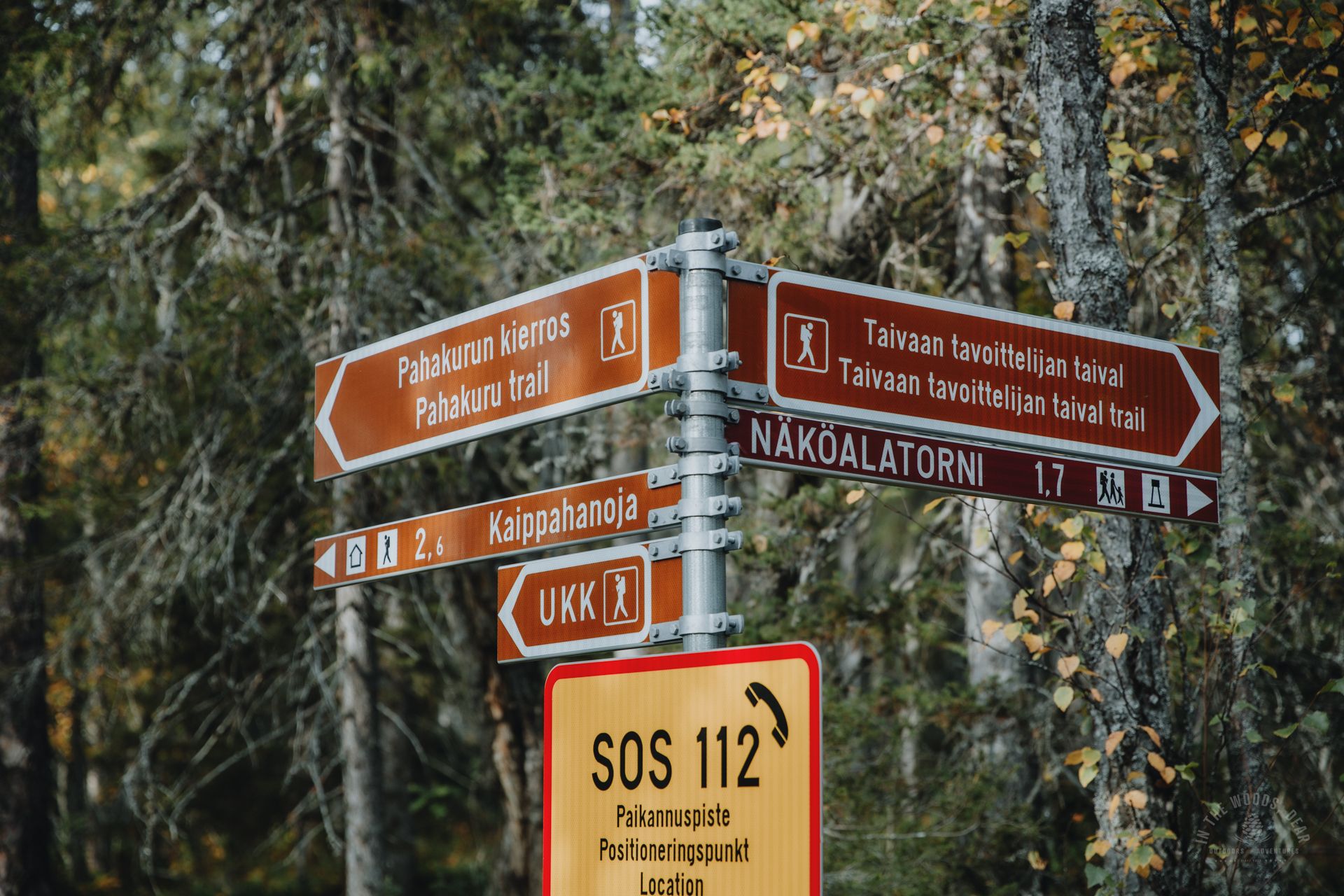
The hiking trails in the Salla area take you to the most beautiful places and varied nature of the national park. In Salla National Park, you can find Sallatunturi's Taivaan tavoittelijan taival Trail, the Kaunisharjun kierros Trail, and the longer Pahakurun kierros Trail.
On the west side of the road, near the Salla visitor centre, you can find the short Kolmiloukkonen Trail. Outside the national park area, marked trails include the Ruuhitunturi Trail, along which you can hike towards Aikkipetsi.
The hiking trails of Salla are suitable for short day trips and novice hikers as the duckboards and gravel make the trails easy to walk.
The nationwide UKK Trail passes through the Sallatunturi area. The section named Topsakantaival leads to Hautajärvi in Salla, which is the starting point of the famous Karhunkierros Bear’s Trail towards Rukatunturi in Kuusamo. North of Salla, the UKK Trail takes you to Tuntsa Wilderness, often called the most beautiful wilderness area in Europe.


Taivaan tavoittelijan taival Trail
Taivaan tavoittelijan taival Trail is located in the area of Salla National Park, just north of the Sallatunturi (Pieni Pyhätunturi) ski slopes. Taivaan tavoittelijan taival Trail used to be a one-way route, starting from the Pohjoisrinteet parking area and returning to the same place. Nowadays, the route around Iso Pyhätunturi fell is a circular trail.
The length of Taivaan tavoittelijan taival Trail is 4.6 kilometers (the previous one-way route was 3.8 km long), and the trail is classified as moderate in some contexts but challenging in others. The estimated hiking time is from one to two hours.
The hike can be done either clockwise or counterclockwise, with the recommended direction being clockwise. The official starting point is the Pohjoisrinteet parking slot (North Slopes) at Tunturikummuntie, 98900 Salla. At least during my own hike, it was also possible to start the trail from the eastern slope side about 600 meters further from the Pohjoisrinteet parking area.
In the autumn of 2023, the construction of the circular trail was still ongoing, and according to Nationalparks.fi website, approximately 400 meters of graveling was left for the summer of 2024. However, the trail can already be hiked as a circular route unless the eastern section is closed due to graveling work.
Part of the trail follows a gravel road. However, in my updated map application, a new trail and duckboards seem to run alongside the road, so the trail's road section is likely to be relocated to the trail.
There is an observation tower on Iso Pyhätunturi. There are no designated campfire sites, water points, or dry toilets along the trail.
The trail is marked with blue squares on tree trunks and sometimes with blue ribbons or dots on rocks. On sections of the UKK Trail, the markings are red.
Taivaan tavoittelijan taival Trail in winter is a snowshoeing route.


Taivaan tavoittelijan taival Trail – route description
I headed on Taivaan tavoittelijan taival Trail from the eastern side, as I was coming from the southern Sallatunturi and the ski slopes. Along the way, there was a new rest area with views of Tunturilammet and a sign with text "Salla in the middle of nowhere," which are found in several places around Salla.
At the edge of the gravel road, there is a sign pointing to Taivaan tavoittelijan taival Trail. Initially, the trail leads through a forest along duckboards. It's worth stopping to listen to the sounds of nature. You might even catch a glimpse of a grouse, which is common in the Salla region.
After crossing the duckboards, you'll traverse a narrow swamp meadow, with a lush coniferous forest awaiting on the other side. The duckboards, three planks wide, are built to ascend the slope. The journey progresses swiftly.
After the swampy area, the slope steepens, and the duckboards come to an end. A beautiful rocky and muddy natural trail winds through tundra vegetation among moss-covered spruce and pine trees. (This section may be graveled.)
A little before reaching the summit, you'll need to cross some large boulders and rocks. However, the rocky terrain is relatively easy, and you won't need to use your hands for support. In the direction of descent, you'll see the beautiful Tunturilammet area from above.
At the summit of Iso Pyhätunturi fell awaits a treeless and rocky peak. The path continues as a graveled and narrow strip towards the observation tower. Along the way, benches are provided for rest breaks.
The observation tower of Iso Pyhätunturi stands proudly atop Sallatunturi. From the tower, you'll enjoy expansive views in all directions, overlooking Salla National Park and its majestic forests. The old Sallatunturit on the Russian side roll into the east, while the mystical Aatsinginhauta gorge beckons from the northeast, and Salla village dots the landscape to the northwest.
In the midst of summer and the nightless night of the Arctic, the summit of Sallatunturit would be an excellent spot to admire the Lapland midnight sun, which never sets below the horizon. Adventurous souls head to the summit in the dark during the spring and autumn seasons to catch a glimpse of the green dancers of the sky, the Northern Lights.
The summit of Sallatunturi is a popular spot for picnics, and especially on longer hikes, a lunch break at the peak is a great experience. Since there are no tables or fireplaces at the summit, you'll need to veer slightly off the trail if you wish to set up your camping stove.
To preserve the delicate tundra vegetation, it's essential to stick to the marked trail. The summit is dotted with large boulders, which you can use to avoid trampling the vegetation. Alternatively, you can take a snack break at the observation platforms built next to the stairs.


If you're traveling counterclockwise, the descent follows the western side of the fell. Long stairs descend steeply from the summit. The steps are made of metal grates with paw-print decorated planks on the sides, which also make hiking enjoyable for furry companions.
At the halfway point of the staircase, there is a viewing platform. The platform features a bench and some grey blocks. The trail then continues as a graveled path through a mixed forest. In early autumn, the woods are painted with shades of yellow and orange, making the landscape glow.
After the gravel path, you'll descend another set of stairs. A similar viewing platform is located a bit further away, offering peace and solitude.
The final stretch of the journey follows a gravel path and gently descends through lush spruce forest. There is a third resting area in the forest.
Just before reaching the border of Salla National Park, you'll come to a junction. To the right, the trail leads to the new Kaippahanoja day hut and the Pahakuru Trail. Taivaan tavoittelijan taival Trail continues from the intersection for another couple of hundred meters to the Pohjoisrinteet parking area.
Salla National Park – my experiences
- I ventured into the area of Salla National Park and its surroundings for the first time in early autumn 2023, when construction was still underway in some places. However, my initial impression of the area was that Salla has a lot of infrastructure everywhere.
- Various sensory points along the different routes add to the constructed feeling. These points feature some signs and instructions on how to listen to the sounds of nature, enjoy the scenery, or feel the gusts of wind, as well as hammocks and lounge chairs designed to provide a relaxing experience. Perhaps these instructions are helpful for someone who is not been to nature much.
- The popular routes were quite busy. Outside the national park, the trails were quiet, but there was often quite a lot of people at the huts and shelters.
- The trails are easily accessible, and there are plenty of parking areas right at the trailheads.
- There were many trails, and in some places, it was challenging to choose the right path, even though there were plenty of signs and trail markings.
- In my opinion, the Salla area is better suited for day hiking than for multi-day long-distance backpacking, at least during the summer season. I found the areas of Ruuhitunturi and Aikkipetsi to be the most beautiful.
- From Salla, it's also a quick drive to the popular trails of Ruka-Kuusamo such as Pieni Karhunkierros (Small Bear's) Trail and beautiful Konttainen, and the trails of Riisitunturi National Park in Posio.


