
Planning your first multi-day solo summer backpacking trip in Finland? Not sure if you should be prepared for snow, mosquitos or polar bears? No worries, getting your ducks in a row is easier than you would guess!
Read more
Finland

Saariselkä in Lapland, Finland is an amazing winter destination for outdoor lovers. From the top of the highest fell Sokosti, you can enjoy incredible views of Lake Luirojärvi and the white fells of Urho Kekkonen National Park. The varied wilderness and one of Finland's densest networks of open wilderness huts make the area very popular for year-round hiking adventures.
I did a six-day backcountry skiing tour to Sokosti fell and Lake Luirojärvi in Urho Kekkonen National Park in March. I skied about 100 km / 62 miles, with an elevation gain of 2022 m / 6634 ft. The frosts were severe, often exceeding -30°C (-22°F) degrees at night.
Read more
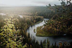
Karhunkierros (The Bear's Trail) is the most famous long hiking trail in Finland. The 82-kilometre "legendary trail" runs through the Oulanka National Park in the Salla and Kuusamo areas, combining the most spectacular natural sites in the Northeastern part of Finland in one single experience. I have hiked Karhunkierros and visited its trails and attractions 16 times in different seasons - and this guidebook contains detailed instructions and tips based on my own experiences.
For many Finns, Karhunkierros is their first long hike. For the first-timer (either first hike ever or first hike in Finland), there are many qualities that make it a great trek: the route is well marked, there are no water crossings, and there are numerous huts and shelters along the way. There are also some restaurants along the way and several places to get off the hike if necessary.
Every guide praises Karhunkierros hike and says it should be on every hiker's bucket list. In reality, some people don't like it, some don't care, and for some the Karhunkierros hike is a wonderful, even life-changing experience.
In this guide you will find "everything about Karhunkierros" to help you plan and do your own hike - whether you are on your first long hike or are setting off for the first time on Finland's most legendary hiking trail!
Read more
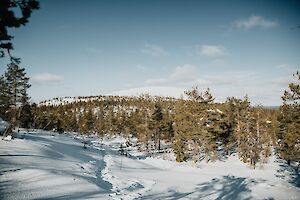
The Lampivaara Amethyst Mine winter trail invites you to walk and snowshoe in the snowy old forests of Luosto, Lapland. In the frosts of January and February, the landscape is particularly fairytale-like, with the crown-snow trees painting a beautiful nature scene. In March and April, the deep green of the forest and the rays of the spring sun on the slopes are the best part of the hike.
Along the Lampivaara trail, you climb to the top of Pikku-Luosto fell, with sweeping views of the snowy Ukko-Luosto peak and the surrounding fells in the distance. At Lampivaara, the hike can be completed with a guided visit to an amethyst mine or by stopping for a coffee at the café.
Read more

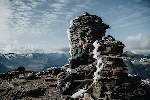
Ukko-Luosto (514 m) is the highest fell peak in the Luosto area, Lapland, Finland. Located in the Pyhä-Luosto National Park, Ukko-Luosto is accessible in winter for skiing, snowshoeing and walking.
If you are tempted by the white shimmering peak of Ukko-Luosto, this article will give you the route and tips for the hike. In the article you will also find a map of Pyhä-Luosto area, where the Ukko-Luosto route in winter is marked.
Read more

Tunturiaapa nature trail is located in Pyhä, at the southern part of Pyhä-Luosto National Park. From the vast open mire you'll get great views of the peaks of the Pyhätunturi fells.
The Tunturiaapa nature trail is accessible all year round. In winter, you may admire the beautiful landscape with the northern lights, the dazzling evening sky, frost-covered trees or the bright blue sky against a backdrop of white-peaked fells.
The trail is mostly flat terrain and is quite easy in winter, too. Here's the route description and tips for a 10 km walk or snowshoe hike.
Read more
Parastinden in Norway is a favourite mountain especially among Finnish hikers. The mountain, which resembles a shark's fin, can be climbed on a short day trip from Rognli in Norway, or on a longer hike from Kilpisjärvi in Finland.
Read more
The Arctic Trail is a demanding 800-kilometre hiking trail along the borders of northern Finland, Norway and Sweden. You don't have to hike the entire Arctic Trail in one go, but can do it in many different sections.
Read more

Sipoonkorpi National Park is a place to admire the majestic mossy cliffs and walk through dense, wilderness-like coniferous forests. Fiskträsk is a beautiful wilderness lake, that you can reach with a quick hike to its shores and a new campfire site.
Read more

Kukastunturi (477 m) is one of the easiest routes in Ylläs Lapland to the top of fells. Located in Pallas-Yllästunturi National Park in Finland, the Kukastunturi summit offers great views in all directions. The most convenient way to hike Kukastunturi is from Karila.
Read more