Destinations // 2 March 2023
Valtavaara fell in winter is one of the most popular hiking destinations in Ruka, Finland. Valtavaara is the highest protected fell in Kuusamo, the peak reaching 491 meters. In clear weather, amazing landscapes open up from the top of Valtavaara to northern Kuusamo and Russia to the east.
The nature area of Valtavaara-Pyhävaara offers incredibly beautiful views of the hill and fell landscape. The nature area has many routes for day hikes, as well as the famous Karhunkierros Bear’s Trail hiking trail that goes through the peak of Valtavaara. Ruka's Valtavaara area is great for both summer and winter hiking.
The Ruka-Kuusamo region has endless trails to experience for winter hikers. In addition to Valtavaara in Ruka, the top destinations for winter hikers are Konttainen and Pyhävaara, as well as the beautiful routes of Oulanka National Park and the views of Karhunkierros Bear’s Trail in winter. A popular destination for photographers, Riisitunturi in Posio, is also only a short drive away.
Ruka also has wonderful slopes and a diverse network of cross-country skiing tracks. For example, you can ski around Rukankylä village along a lighted track.
Read more
Valtavaara winter trail
Destination: Ruka, Kuusamo, Finland
Difficulty: demanding
When to go: From December to April (year-round)
Duration: 3 hours, a half-day trip snowshoeing or by foot
Destinations // 28 February 2023
Sipoonkorpi National Park in eastern Uusimaa is an easily accessible hiking destination in the capital region. From Helsinki, you can reach the national park in less than half an hour. Sipoonkorpi offers beautiful nature to take a break from the hustle and bustle of everyday life, hiking on forest trails and traditional rural landscapes.
Read more
Byabäcken nature trail in winter
- Destination: Sipoo, Finland
- Distance: 2.1 km (1.3 miles)
- Difficulty: Easy
- Duration: 1-1.5 hours, snowshoeing or by foot
Destinations // 17 February 2023
Sipoonkorpi National Park in eastern Uusimaa is a green oasis for the people living in the capital region. It takes less than half an hour to reach the national park from Helsinki. As its name suggests, Sipoonkorpi (= Sipoo’s Woods) offers deep forests as well as rural traditional landscapes.
Read more
Adventures // 3 February 2023
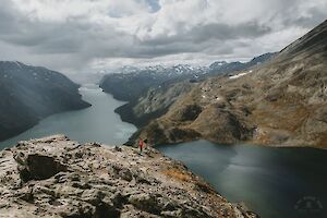
Besseggen hike is one of the most popular mountain hikes in Norway, and the most beautiful trail in Jotunheimen National Park. Besseggen Ridge has been listed as one of the top 20 best hikes in the world by National Geographic. To hike the scenic Besseggen trail and see the panoramic view over the mountainous Norway, you just have to climb up to 1743 m.a.s.l. with 1,200 meters of elevation gain.
Read more
Besseggen hike in Jotunheimen National Park
- Destination: Jotunheimen National Park, Tessanden, Norway
- Distance: 14 km (elevation gain 1,200 m)
- Difficulty: demanding +, the Besseggen ridge is challenging
- When to go: from June to September for a summer hike
- Duration: a daytrip, 6-8 hours (or enjoy the whole day with lunch & taking pictures!)
- Where to stay: camping free on the beach (can be crowded Fri-Sun), or at Gjendesheim Tourist Lodge, or in Memurubu
Trail Run // 24 January 2023
Barden mountain (659 m) is located on the north side of the island of Senja in Norway, close to Segla and Hesten. All three mountains can be hiked from Fjordgård. Segla and Hesten are more famous than Barden, but the Barden hike is a local favorite – and it was also my favorite in Senja.
Read more
Senja Barden info
- Destination: Fjordgård (Mefjordbotn), Senja, Norway
- Distance: 3.3 km one way from Fjordgård
- Difficulty: (easy to) moderate
- Duration: 3-4 h (hiking, faster by trail running)
- When to go: June to September
- Where to stay: wild camping in the mountains, hotel accommodation in Fjordgård
Choosing the right sleeping bag and sleeping pad for lightweight and ultralight backpacking may seem like a daunting task with all the various ratings and ever-increasing options. We are often advised to first think about what kind of backpacker you are: do you enjoy road trips and camping, or do you hike in a traditional style or do you want to shave as much weight as possible.
Read more
Trail Run // 15 January 2023
Within short distance from Hamn i Senja in Senja Island, Norway rises the small but wonderful panoramic view offering Sukkertoppen (456 m) mountain. Sukkertoppen or "Sugar Peak" is well suited for both trail running and hiking. The route is short, just over two kilometers in one direction, and very steep in places.
Read more
Sukkertoppen, Senja Island
- Destination: Skaland, Senja, Norway
- Distance: 2.1 km one way
- Difficulty: medium, last stretch demanding (difficult in rain)
- Duration: 2 h (hiking, faster by trail running)
- When to go: June to August
- Where to stay: In the hotels of Hamn, you may find a place for a tent in Ballesvika
Lightweight backpacking means hiking with lightweight equipment. In lightweight and ultralight backpacking, the focus is on packing only the necessary equipment and on reducing the weight wherever possible.
Read more
Adventures // 9 January 2023
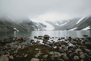
The mysterious Tarfala valley in Lapland Sweden is hidden in the armpit of several 2,000 m high mountain peaks. At the bottom of the valley glitters the turquoise Lake Tarfalajaure (Darfáljávri), the mountains are covered by some of the largest glaciers of Sweden. The rugged and barren Tarfala is one of the most beautiful valleys of the Kebnekaise mountain massif area.
Read more
Tarfala valley hiking info
- Destination: Norrbotten, Lapland, Sweden
- Distance: 6 km, from Kebnekaise mountain station 8 km
- Difficulty: physically demanding but quite easy
- When to go: from June to August for a summer hike
- Duration: a daytrip, or part of a multiday backpacking trip
- Where to stay: camping with or without facilities, or at STF's mountain cabins
Trail Run // 4 January 2023
If a year could be a low rated movie, it would probably look like 2022. At the end of January, my mother unexpectedly passed away, and in the middle of February I got corona. Difficult symptoms lasted a long time.
Read more