Mountains

Blåisvatnet in Lyngen Alps Norway: Hike to the Blue Lake

If you've seen a dazzling blue lake in pics of Norway's Lyngen Alps, the pics may look dazzling without much extra saturation. The glacial Lake Blåisvatnet or Blåvatnet ("Blue Lake", Jiehkkejávri) looks almost surreal in the middle of the barren mountain nature – so brilliant is its turquoise-tinged blue color.

Read more

Blåvatnet "Blue Lake" hike

  • Destination: Sør-Lenangsbotn, Lyngen, Norway
  • Distance: 4 km / 2.5 miles one-way
  • Difficulty: quite easy
  • Duration: 3 h (roundtrip)
  • When to go: June to September

Hesten in Senja: Segla's Beautiful But Crowded Neighbor

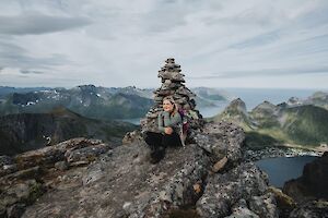
Hesten (556 m / 1824 ft) is one of the most famous destinations on Senja Island, along with the neighboring Segla mountain. The peaks are located north of the island of Senja, in Fjordgård. Hesten is probably the most popular "Instagram mountain" in Senja Norway – the epic photos of Segla are mainly taken from Hesten.

Read more

Hesten, Senja

  • Destination: Fjordgård, Senja, Norway
  • Distance: 2.3 km (1.43 miles) one way
  • Difficulty: moderate / demanding (a bit challenging climbing at the top)
  • Duration: 2-3 h
  • When to go: June to September
  • Where to stay: camping in the mountains, hotel accommodation in Fjordgård

Grytetippen (885 m, 2903 ft) and Keipen (938 m, 3077 ft) belong to the highest and most majestic mountains on the northern side of the Norway’s Senja Island. From the top of Grytetippen you can see almost all of Senja's most famous mountains: dramatic Segla and on both sides Barden and Hesten above Fjordgård village, Senja's highest mountain Breitinden in the southwest and the popular Riven near the island of Husøy.

Read more

Grytetippen and Keipen hike

  • Destination: Fjordgård / Mefjordbotn, Senja, Norway
  • Distance: 4,5 km (2.8 miles) one direction from Fylkesveien road
  • Difficulty: moderate challenging (marked as red)
  • Duration: 5-8 h
  • When to go: from June to September
  • Where to stay: camping in the mountains or next to the road, hotel accommodation at Fjordgård

The 8 Best Hikes in Jotunheimen National Park Norway

Jotunheimen National Park is an outdoor enthusiast's paradise and end of the rainbow for those who love hiking in the mountains. Jotunheimen is Norway's most mountainous region. In Jotunheimen you will find Norway's highest mountains, turquoise lakes, green valleys and even one of the world's TOP 20 most exciting hiking trails.

Read more


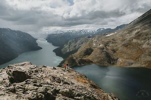
Besseggen hike is one of the most popular mountain hikes in Norway, and the most beautiful trail in Jotunheimen National Park. Besseggen Ridge has been listed as one of the top 20 best hikes in the world by National Geographic. To hike the scenic Besseggen trail and see the panoramic view over the mountainous Norway, you just have to climb up to 1743 m.a.s.l. with 1,200 meters of elevation gain.

Read more

Besseggen hike in Jotunheimen National Park

  • Destination: Jotunheimen National Park, Tessanden, Norway
  • Distance: 14 km (elevation gain 1,200 m)
  • Difficulty: demanding +, the Besseggen ridge is challenging
  • When to go: from June to September for a summer hike
  • Duration: a daytrip, 6-8 hours (or enjoy the whole day with lunch & taking pictures!)
  • Where to stay: camping free on the beach (can be crowded Fri-Sun), or at Gjendesheim Tourist Lodge, or in Memurubu

Barden on Senja Island – The Scenic Sunset Mountain

Barden mountain (659 m) is located on the north side of the island of Senja in Norway, close to Segla and Hesten. All three mountains can be hiked from Fjordgård. Segla and Hesten are more famous than Barden, but the Barden hike is a local favorite – and it was also my favorite in Senja.

Read more

Senja Barden info

  • Destination: Fjordgård (Mefjordbotn), Senja, Norway
  • Distance: 3.3 km one way from Fjordgård
  • Difficulty: (easy to) moderate
  • Duration: 3-4 h (hiking, faster by trail running)
  • When to go: June to September
  • Where to stay: wild camping in the mountains, hotel accommodation in Fjordgård

Sukkertoppen – The Beautiful Peak in Senja Norway

Within short distance from Hamn i Senja in Senja Island, Norway rises the small but wonderful panoramic view offering Sukkertoppen (456 m) mountain. Sukkertoppen or "Sugar Peak" is well suited for both trail running and hiking. The route is short, just over two kilometers in one direction, and very steep in places.

Read more

Sukkertoppen, Senja Island

  • Destination: Skaland, Senja, Norway
  • Distance: 2.1 km one way
  • Difficulty: medium, last stretch demanding (difficult in rain)
  • Duration: 2 h (hiking, faster by trail running)
  • When to go: June to August
  • Where to stay: In the hotels of Hamn, you may find a place for a tent in Ballesvika

Tarfala in Swedish Lapland - Hiking to the Glacier Valley

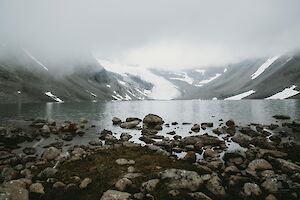
The mysterious Tarfala valley in Lapland Sweden is hidden in the armpit of several 2,000 m high mountain peaks. At the bottom of the valley glitters the turquoise Lake Tarfalajaure (Darfáljávri), the mountains are covered by some of the largest glaciers of Sweden. The rugged and barren Tarfala is one of the most beautiful valleys of the Kebnekaise mountain massif area.

Read more

Tarfala valley hiking info

  • Destination: Norrbotten, Lapland, Sweden
  • Distance: 6 km, from Kebnekaise mountain station 8 km
  • Difficulty: physically demanding but quite easy
  • When to go: from June to August for a summer hike
  • Duration: a daytrip, or part of a multiday backpacking trip
  • Where to stay: camping with or without facilities, or at STF's mountain cabins

Fannaråken Hike in Jotunheimen National Park in Norway

The Fannaråken hike is one of the classic hikes in Norway's Jotunheimen National Park. Fannaråken (or Fannaråki) is a Scandinavian mountain, with a peak rising 2068 meters above sea level. From Fannaråki, stunning landscapes open up to western Jotunheimen.

Read more

Fannaråken hike

  • Destination: Jotunheimen National Park, Luster, Norway
  • Route length: 15 km from Turtagrø (ascent approx. 1200 meters)
  • Difficulty: medium
  • Travel time: day trip 8 hours
  • When to go: July to August
  • Where to stay: in a tent without amenities, at Turtagrø Hotel with amenities (and then there's the back seat of the car for real adventurers :D)

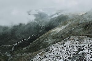
Sarek National Park is located in Swedish Lapland, in Jokkmokk Municipality. The ruggedly beautiful Sarek is the oldest national park in Europe, and it is often called the last great wilderness of the North. Six out of thirteen peaks over 2,000 m are located within the boundaries of the national park, and there are around 100 glaciers.

Read more

Hiking in Sarek National Park

  • Destination: Jokkmokk Municipality, Lapland, Sweden
  • Distance: Around 72 km (From Suorva to Skierfe, without summits)
  • Difficulty: advanced / difficult (mountaineous wilderness), no marked trails, big river crossings, challenging weather 
  • When to go: from June to August for a summer hike  
  • Duration: multi-day adventure, a daytrip to Skierfe from Aktse
  • Where to stay: in a tent