Mountains

Kebnekaise Hike: Climbing Solo the Highest Peak in Sweden

Kebnekaise (Giebmegáisi in Sámi) is Sweden’s highest mountain, its summit reaching 2,097 m. It has two peaks, the southern Sydtoppen and the northern Nordtoppen. Kebnekaise is located in North Sweden around 80 kilometers from Kiruna. It’s a real Swedish classic hike in a high alpine environment.

Read more

Kebnekaise hike info

  • Destination: Norrbotten, Lapland, Sweden
  • Distance: 18 km (elevation gain 1,800 m) from Kebnekaise fell station
  • Difficulty: physically demanding but quite easy
  • When to go: from June to August for a summer hike
  • Duration: a daytrip, 10-14 hours
  • Where to stay: camping with or without facilities, or at Kebnekaise mountain lodge

Hiking in Lofoten: Haukland Beach and Veggen (489 m)

While the Kvalvika beach is the iconic beach of Lofoten Islands, Haukland beach is definitely a ‘must see’ arctic paradise as well. It’s probably the most famous beach for swimming and SUP boarding, with easy access by car (no climbing needed, the parking area is by the beach) or by public transportation.

Read more

Haukland Beach and Veggen hike info

  • Destination: Lofoten islands, Haukland/Uttakleiv Vestvågøy, Norway
  • Distance: Veggen hike 1,8 km (489 m)
  • Difficulty: easy to moderate, some steep sections
  • When to go: from June to August for a summer hike
  • Duration: a daytrip 2+ hours (Veggen hike)
  • Where to stay: camping by the beach (Haukland beach or Uttakleiv camping site)

Backpacking in Swedish Lapland: Vistas Valley

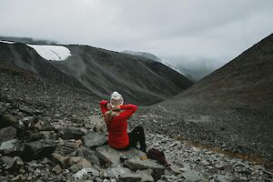
Vistas valley (Vistasdalen in Swedish, Vistasvagge in Sami) is a green oasis in high-alpine environment in Swedish Lappland near Kebnekaise. The trail runs between Nikkaluokta and Alesjaure along river Vistasjohka in the wide valley surrounded by mountains. The trail is well-marked all the way. You can also hike the 84 km trail from Nikkaluokta to Abisko through Vistas valley. There’s a mountain cabin, Vistastugan, in the middle of the valley providing facilities, such as accommodation for hikers. The river is popular for paddling trips as well. Sometimes you may spot Scandinavian elks wandering in the valley – I did!

Read more

Vistas valley hiking info

  • Destination: Vistas/Vistasdalen, Norrbotten, Lapland, Sweden
  • Distance: Alesjaure-Nikkaluokta 55 km (one direction)
  • Difficulty: easy-moderate, includes easy river/stream crossings
  • When to go: from July to August for a summer hike
  • Duration: 2-3 days
  • Where to stay: camping in tent, or Vistastugan mountain lodge

Galdhøpiggen hike: On the top of Scandinavia

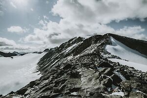
Galdhøpiggen summit in Norway's Jotunheimen National Park is the highest point of Scandinavia and Northern Europe. To reach an astonishing panoramic view over the mountainous Norway, you just have to climb up to 2469 m.a.s.l. with around 1,500 meters of elevation gain.

Read more

Galdhøpiggen hike info

  • Destination: Jotunheimen National Park, Lom, Norway
  • Distance: 13 km (elevation gain 1,500 m) from Spiterstulen
  • Difficulty: physically demanding but quite easy
  • When to go: from June to August for a summer hike
  • Duration: a daytrip, 7-9 hours
  • Where to stay: camping with or without facilities, or at Spiterstulen Tourist Lodge

I walked on the spectacular Kvalvika Beach in Lofotodden National Park in Lofoten Islands already fifteen years ago on my diving and hiking trip to Norway. Back then the day-hike was quiet, and the beach was empty (in the middle of July!), with just the ice-cold emerald green water roaring on the white sand between massive vertical cliffs rising straight from the ocean.

Read more

Kvalvika Beach and Ryten hike info

  • Destination: Lofoten Islands, Fredvang Moskenesøy, Norway
  • Distance: 2 km (elevation gain 200+ m), Kvalvika-Ryten 2,5 km (elevation gain 543 m)
  • Difficulty: easy, Kvalvika-Ryten moderate 
  • When to go: from June to August for a summer hike, accessible any time of the year
  • Duration: a daytrip 2-3 hours (just Kvalvika), 4-6 hours (Ryten through Kvalvika), or overnight camping by the beach