
Husedalen is a valley of stunning waterfalls in Hardangervidda National Park and one of the most beautiful valleys in Norway. The four waterfalls hike leads to breathtaking viewpoints and close to the roaring water.
Read more
Norway

Bondhusvatnet is a glacial lake located in Sunndal, Norway, about a 2.5 hour's drive from Bergen. Bondhusvatnet is one of the most popular hiking destinations in the Hardanger region and also the most popular "Instagram photo spot".
Read more
Husfjellet is located northeast of Senja Island in Northern Norway, close to popular attractions such as Tungeneset and Ersfjorden Beach. Husfjellet is praised as one of the most rewarding hiking destinations in Senja. Although the hike is classified as challenging, the ascent is mostly gradual, and the scenery is breathtaking throughout the journey.
Read more

Dalberget hike in Lyngen Alps, Norway is an easy to moderate ascent through a lush forest along a path above the tree line. From the top, incredibly beautiful panoramic views open up to the Lyngenfjord and the snow-capped mountains of the Lyngen Alps.
Read more

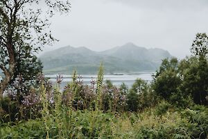
At the northernmost tip of Lyngen peninsula in Norway, hides a little red cottage, Lyngstuva. On a summer hiking trip to Lyngstuva Lighthouse, you can admire coastal walks and landscapes, discover the historic site, and experience the incredible midnight sun and blazing sunset.
Read more

If you've seen a dazzling blue lake in pics of Norway's Lyngen Alps, the pics may look dazzling without much extra saturation. The glacial Lake Blåisvatnet or Blåvatnet ("Blue Lake", Jiehkkejávri) looks almost surreal in the middle of the barren mountain nature – so brilliant is its turquoise-tinged blue color.
Read more

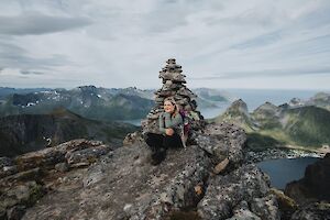
Festvågtinden (541 m / 1775 ft) rising next to Henningsvær village, south of Austvågøy island, is one of the most popular hiking trails in Lofoten, Norway. From the top of Festvågtinden there is an incredible view as the sun sets on the horizon behind the Lofoten mainland.
Read more

Hesten (556 m / 1824 ft) is one of the most famous destinations on Senja Island, along with the neighboring Segla mountain. The peaks are located north of the island of Senja, in Fjordgård. Hesten is probably the most popular "Instagram mountain" in Senja Norway – the epic photos of Segla are mainly taken from Hesten.
Read more
Grytetippen (885 m, 2903 ft) and Keipen (938 m, 3077 ft) belong to the highest and most majestic mountains on the northern side of the Norway’s Senja Island. From the top of Grytetippen you can see almost all of Senja's most famous mountains: dramatic Segla and on both sides Barden and Hesten above Fjordgård village, Senja's highest mountain Breitinden in the southwest and the popular Riven near the island of Husøy.
Read more

Jotunheimen National Park is an outdoor enthusiast's paradise and end of the rainbow for those who love hiking in the mountains. Jotunheimen is Norway's most mountainous region. In Jotunheimen you will find Norway's highest mountains, turquoise lakes, green valleys and even one of the world's TOP 20 most exciting hiking trails.
Read more