Adventures // 3 February 2023
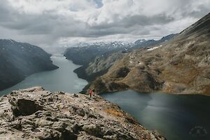
Besseggen hike is one of the most popular mountain hikes in Norway, and the most beautiful trail in Jotunheimen National Park. Besseggen Ridge has been listed as one of the top 20 best hikes in the world by National Geographic. To hike the scenic Besseggen trail and see the panoramic view over the mountainous Norway, you just have to climb up to 1743 m.a.s.l. with 1,200 meters of elevation gain.
Read more
Besseggen hike in Jotunheimen National Park
- Destination: Jotunheimen National Park, Tessanden, Norway
- Distance: 14 km (elevation gain 1,200 m)
- Difficulty: demanding +, the Besseggen ridge is challenging
- When to go: from June to September for a summer hike
- Duration: a daytrip, 6-8 hours (or enjoy the whole day with lunch & taking pictures!)
- Where to stay: camping free on the beach (can be crowded Fri-Sun), or at Gjendesheim Tourist Lodge, or in Memurubu
Trail Run // 24 January 2023
Barden mountain (659 m) is located on the north side of the island of Senja in Norway, close to Segla and Hesten. All three mountains can be hiked from Fjordgård. Segla and Hesten are more famous than Barden, but the Barden hike is a local favorite – and it was also my favorite in Senja.
Read more
Senja Barden info
- Destination: Fjordgård (Mefjordbotn), Senja, Norway
- Distance: 3.3 km one way from Fjordgård
- Difficulty: (easy to) moderate
- Duration: 3-4 h (hiking, faster by trail running)
- When to go: June to September
- Where to stay: wild camping in the mountains, hotel accommodation in Fjordgård
Trail Run // 15 January 2023
Within short distance from Hamn i Senja in Senja Island, Norway rises the small but wonderful panoramic view offering Sukkertoppen (456 m) mountain. Sukkertoppen or "Sugar Peak" is well suited for both trail running and hiking. The route is short, just over two kilometers in one direction, and very steep in places.
Read more
Sukkertoppen, Senja Island
- Destination: Skaland, Senja, Norway
- Distance: 2.1 km one way
- Difficulty: medium, last stretch demanding (difficult in rain)
- Duration: 2 h (hiking, faster by trail running)
- When to go: June to August
- Where to stay: In the hotels of Hamn, you may find a place for a tent in Ballesvika
Adventures // 14 December 2022
The Fannaråken hike is one of the classic hikes in Norway's Jotunheimen National Park. Fannaråken (or Fannaråki) is a Scandinavian mountain, with a peak rising 2068 meters above sea level. From Fannaråki, stunning landscapes open up to western Jotunheimen.
Read more
Fannaråken hike
- Destination: Jotunheimen National Park, Luster, Norway
- Route length: 15 km from Turtagrø (ascent approx. 1200 meters)
- Difficulty: medium
- Travel time: day trip 8 hours
- When to go: July to August
- Where to stay: in a tent without amenities, at Turtagrø Hotel with amenities (and then there's the back seat of the car for real adventurers :D)
Adventures // 28 July 2022
While the Kvalvika beach is the iconic beach of Lofoten Islands, Haukland beach is definitely a ‘must see’ arctic paradise as well. It’s probably the most famous beach for swimming and SUP boarding, with easy access by car (no climbing needed, the parking area is by the beach) or by public transportation.
Read more
Haukland Beach and Veggen hike info
- Destination: Lofoten islands, Haukland/Uttakleiv Vestvågøy, Norway
- Distance: Veggen hike 1,8 km (489 m)
- Difficulty: easy to moderate, some steep sections
- When to go: from June to August for a summer hike
- Duration: a daytrip 2+ hours (Veggen hike)
- Where to stay: camping by the beach (Haukland beach or Uttakleiv camping site)
Adventures // 4 November 2021
Galdhøpiggen summit in Norway's Jotunheimen National Park is the highest point of Scandinavia and Northern Europe. To reach an astonishing panoramic view over the mountainous Norway, you just have to climb up to 2469 m.a.s.l. with around 1,500 meters of elevation gain.
Read more
Galdhøpiggen hike info
- Destination: Jotunheimen National Park, Lom, Norway
- Distance: 13 km (elevation gain 1,500 m) from Spiterstulen
- Difficulty: physically demanding but quite easy
- When to go: from June to August for a summer hike
- Duration: a daytrip, 7-9 hours
- Where to stay: camping with or without facilities, or at Spiterstulen Tourist Lodge
Adventures // 7 October 2021
Would you like to experience scenic, out-of-this-world views, without the disturbance of 100 other people? Hike to Horseidvika and the Horseid Beach in Lofoten Islands! The Horseid Beach (Horseidvika) is one of the most difficult beaches to reach in Lofoten Islands, as it basically requires a ferry trip and several hours of hiking unlike the easier destinations Kvalvika Beach and Haukland Beach. But the reward from the effort is something to remember.
Read more
Horseid Beach hike info
- Destination: Lofoten islands, Reine, Moskenesøy, Norway
- Distance: 4.5 km / 2.8 miles (one way)
- Difficulty: easy
- When to go: from June to August for a summer hike
- Duration: a daytrip 10 hours (5-7 hours for the hike), or overnight camping by the beach
Adventures // 9 September 2021
I walked on the spectacular Kvalvika Beach in Lofotodden National Park in Lofoten Islands already fifteen years ago on my diving and hiking trip to Norway. Back then the day-hike was quiet, and the beach was empty (in the middle of July!), with just the ice-cold emerald green water roaring on the white sand between massive vertical cliffs rising straight from the ocean.
Read more
Kvalvika Beach and Ryten hike info
- Destination: Lofoten Islands, Fredvang Moskenesøy, Norway
- Distance: 2 km (elevation gain 200+ m), Kvalvika-Ryten 2,5 km (elevation gain 543 m)
- Difficulty: easy, Kvalvika-Ryten moderate
- When to go: from June to August for a summer hike, accessible any time of the year
- Duration: a daytrip 2-3 hours (just Kvalvika), 4-6 hours (Ryten through Kvalvika), or overnight camping by the beach