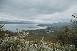
Abisko National Park in northern Sweden is a popular hiking destination throughout the year. The most stunning attractions and photography spots of Abisko are easily accessible, even for those who prefer shorter and less challenging hikes. Short trails and viewpoints near the road are suitable even for the busy traveler – you can see a lot in a day.
Read more
Summer

Abisko serves as the gateway to nature in northern Sweden, offering the most breathtaking attractions and easily accessible trails. Numerous hiking routes originate from Abisko, ranging from short day hikes to treks covering hundreds of kilometers.
Read more

Saivonkierros nature trail in Ylläs Lapland leads you through a pine forest to a steep rock Seitapahta and a ravine lake surrounded by rocks, Äkässaivo. Äkässaivo is located just at the border of Pallas-Yllästunturi National Park in Finland. Ylläs and Kellokas Visitor Centre are twenty minutes away by car.
Read more

Aakenustunturi fell rises in western Kittilä, right next to Ylläs, in Pallas-Yllästunturi National Park in Lapland. Aakenustunturi fell has three high peaks, Pallilaki (565 m / 1854 ft), Moloslaki (530 m / 1739 ft) and Vasalaki (470 m / 1542 ft). The Aakenustunturi trail, Moloslaki Trail, goes through Vasalaki.
Read more

Kungsleden, or King's Trail, is the most famous hiking trail in northern Sweden. The hiking trail is over 400 kilometers (249 miles) long, going from Abisko to Hemavan through rugged landscapes. The most popular stretch of the Kungsleden hikes is the Abisko-Nikkaluokta route.
Read more

Rokua National Park is part of Rokua Geopark, which was the first in Finland to be selected as one of UNESCO's unique geological sites. The geopark also includes the areas of Lake Oulujärvi and Oulujokilaakso River Valley.
Read more

Dalberget hike in Lyngen Alps, Norway is an easy to moderate ascent through a lush forest along a path above the tree line. From the top, incredibly beautiful panoramic views open up to the Lyngenfjord and the snow-capped mountains of the Lyngen Alps.
Read more

At the northernmost tip of Lyngen peninsula in Norway, hides a little red cottage, Lyngstuva. On a summer hiking trip to Lyngstuva Lighthouse, you can admire coastal walks and landscapes, discover the historic site, and experience the incredible midnight sun and blazing sunset.
Read more

If you've seen a dazzling blue lake in pics of Norway's Lyngen Alps, the pics may look dazzling without much extra saturation. The glacial Lake Blåisvatnet or Blåvatnet ("Blue Lake", Jiehkkejávri) looks almost surreal in the middle of the barren mountain nature – so brilliant is its turquoise-tinged blue color.
Read more

Festvågtinden (541 m / 1775 ft) rising next to Henningsvær village, south of Austvågøy island, is one of the most popular hiking trails in Lofoten, Norway. From the top of Festvågtinden there is an incredible view as the sun sets on the horizon behind the Lofoten mainland.
Read more