
The Sevettijärvi-Pulmanki Trail is the most popular hiking trail going through Kaldoaivi wilderness. Kaldoaivi is the largest wilderness area in Finland. The 2924 sq.km wilderness area is located in Utsjoki, in Northern Lapland. The landscape varies from fell highlands to dense birch forests, with countless lakes and river valleys.
Read more
Summer

Halti is the highest fell in Finland with the peak, Háldičohkka, at 1324 m above the sea level. The trail to Halti from Kilpisjärvi, the Arctic Trail or Nordkalott Trail, is the most popular route to Halti from Finland, but several unmarked routes through wilderness lead to Halti as well. I chose the Nordkalott route on my way to Halti but hiked back to Kilpisjärvi via Termisjärvi, following the Arctic Trail to the Kuonjarjoki hut before taking my own path.
Read more

Halti is the highest fell in Finland with the peak, Háldičohkka, at 1324 m above the sea level. It can be summitted from Finland or from Norway as the fell is located at the border between two countries. The trail to Halti from Kilpisjärvi, the Arctic Trail (Nordkalott Trail), is the most popular route to Halti from Finland.
Read more
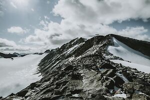
Galdhøpiggen summit in Norway's Jotunheimen National Park is the highest point of Scandinavia and Northern Europe. To reach an astonishing panoramic view over the mountainous Norway, you just have to climb up to 2469 m.a.s.l. with around 1,500 meters of elevation gain.
Read more

Would you like to experience scenic, out-of-this-world views, without the disturbance of 100 other people? Hike to Horseidvika and the Horseid Beach in Lofoten Islands! The Horseid Beach (Horseidvika) is one of the most difficult beaches to reach in Lofoten Islands, as it basically requires a ferry trip and several hours of hiking unlike the easier destinations Kvalvika Beach and Haukland Beach. But the reward from the effort is something to remember.
Read more

Nuuksio National Park in southern Finland is less than an hour's drive from Helsinki. Its easy accessibility makes it ideal for beginner hikers. Although Nuuksio is a relatively urban nature area, the park is full of beautiful untouched forests and swamps, rugged cliffs, and sparkling lakes and ponds. The lucky and discerning outdoor enthusiast might also spot a tiny flying squirrel at dusk!
Read more

I walked on the spectacular Kvalvika Beach in Lofotodden National Park in Lofoten Islands already fifteen years ago on my diving and hiking trip to Norway. Back then the day-hike was quiet, and the beach was empty (in the middle of July!), with just the ice-cold emerald green water roaring on the white sand between massive vertical cliffs rising straight from the ocean.
Read more

The most popular hiking trail in Finland is Karhunkierros, also known as the Bear’s Trail. It takes you through the Oulanka National Park to beautiful forests and scenic views by the swirling River Oulankajoki. The difficulty level varies from easy to more challenging, but I don’t think there are any difficult parts really, even if you are an unexperienced hiker.
The 82 km trail starts from Hautajärvi village in Lapland’s Salla and ends in Rukatunturi fell in Kuusamo. The legendary Bear’s Trail was my first solo hike in the summer 2020.
This part covers the last 41km. Read also: Getting ready for the Bear's Trail and hiking the first 41 km.
Read more

Karhunkierros, the Bear’s Trail, is the most popular hiking trail in Finland. It takes you through the Oulanka National Park to beautiful forests and scenic views by the swirling River Oulankajoki. The difficulty level varies from easy to more challenging, but I don’t think there are any difficult parts really, even if you are an unexperienced hiker.
The 82 km trail starts from Hautajärvi village in Lapland’s Salla and ends at the Rukatunturi fell in Kuusamo (of course you can hike it the other direction too!)
The legendary Bear’s Trail is kind of a must on every hiker’s bucket list. I hiked alone the Bear’s Trail in the end of June in 2020. It was my first solo hiking adventure, amazing and intensive, a life-changing experience I will remember the rest of my life. This is my hiking story from Salla' Hautajärvi to the mid-point of Karhunkierros Trail (41 km).
You might be interested: Karhunkierros - complete guide (2026)
Read also: Hiking in Finland - What to pack for a week's summer hike?
Read more