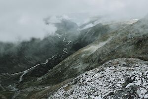
The Fannaråken hike is one of the classic hikes in Norway's Jotunheimen National Park. Fannaråken (or Fannaråki) is a Scandinavian mountain, with a peak rising 2068 meters above sea level. From Fannaråki, stunning landscapes open up to western Jotunheimen.
Read more
Day Trip

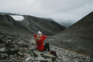
Pyhätunturi is located in Pyhä-Luosto, Lapland. The largest and most famous peak of Pyhätunturi is called "Kultakero". In winter, the summit of Kultakero and the crown-snow trees on the slopes, as well as the vast fell scenery, are a delight for skiers and hikers alike.
The Pyhä ski resort is located in the southernmost large fell area of Finland, in Central Lapland. People often go to Pyhä for skiing, but Pyhä offers great opportunities for all kinds of winter activities.
Conquering the peak of Pyhä on foot or by a scenic lift is a great experience in the winter fells. It's worth going to the top in good weather - the winter sunset on the top of Pyhä is fabulously beautiful!
Read more

Pyhätunturi, Lapland is a popular destination for downhill skiing, but Pyhä winter trails offer also amazing opportunities for cross-country skiing and snowshoeing. Karhunjuomalampi cross-country skiing tour is a magnificent day trip in winter!
Pyhä-Luosto National Park in Central Lapland, is the southernmost great fell area in Finland. It includes the oldest national park in Finland: Pyhä was established already in 1938. During winter, you can admire beautiful crown snow loaded trees and white fell scenery.
Pyhätunturi fell has been a sacred place of the Forest Sámi people. The various names on the area refer to religion and ancient belief. Pyhä (= Holy in English) is a beautiful place for nature pilgrimage year-round.
Read more

Lake Pallasjärvi is located in Western Lapland in Finland, at the border of Kittilä and Muonio. The beautiful lake with red sand beach is in Pallas-Yllästunturi National Park, on the South-East side of Pallastunturi fells. Visiting Lake Pallasjärvi and the Punainenhiekka day hut is convenient to include in a hiking trip such as the classic Hetta-Pallas hike in Pallas-Yllästunturi National Park.
Read more
Kebnekaise (Giebmegáisi in Sámi) is Sweden’s highest mountain, its summit reaching 2,097 m. It has two peaks, the southern Sydtoppen and the northern Nordtoppen. Kebnekaise is located in North Sweden around 80 kilometers from Kiruna. It’s a real Swedish classic hike in a high alpine environment.
Read more

While the Kvalvika beach is the iconic beach of Lofoten Islands, Haukland beach is definitely a ‘must see’ arctic paradise as well. It’s probably the most famous beach for swimming and SUP boarding, with easy access by car (no climbing needed, the parking area is by the beach) or by public transportation.
Read more
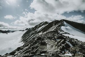
Galdhøpiggen summit in Norway's Jotunheimen National Park is the highest point of Scandinavia and Northern Europe. To reach an astonishing panoramic view over the mountainous Norway, you just have to climb up to 2469 m.a.s.l. with around 1,500 meters of elevation gain.
Read more

Would you like to experience scenic, out-of-this-world views, without the disturbance of 100 other people? Hike to Horseidvika and the Horseid Beach in Lofoten Islands! The Horseid Beach (Horseidvika) is one of the most difficult beaches to reach in Lofoten Islands, as it basically requires a ferry trip and several hours of hiking unlike the easier destinations Kvalvika Beach and Haukland Beach. But the reward from the effort is something to remember.
Read more

I walked on the spectacular Kvalvika Beach in Lofotodden National Park in Lofoten Islands already fifteen years ago on my diving and hiking trip to Norway. Back then the day-hike was quiet, and the beach was empty (in the middle of July!), with just the ice-cold emerald green water roaring on the white sand between massive vertical cliffs rising straight from the ocean.
Read more