Hiking in Lofoten: the Iconic Kvalvika Beach and Ryten (543 m)
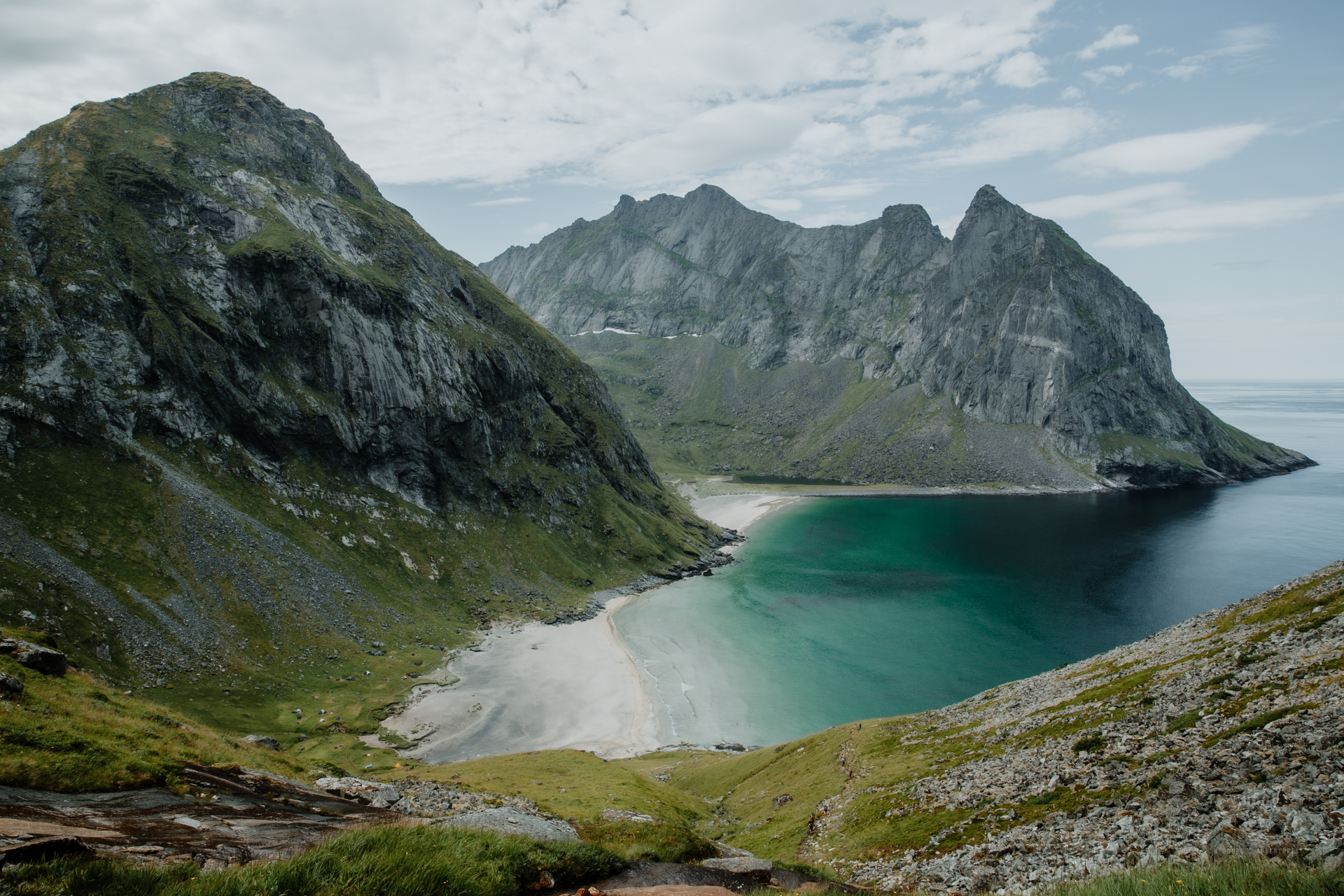
I walked on the spectacular Kvalvika Beach in Lofotodden National Park in Lofoten Islands already fifteen years ago on my diving and hiking trip to Norway. Back then the day-hike was quiet, and the beach was empty (in the middle of July!), with just the ice-cold emerald green water roaring on the white sand between massive vertical cliffs rising straight from the ocean.
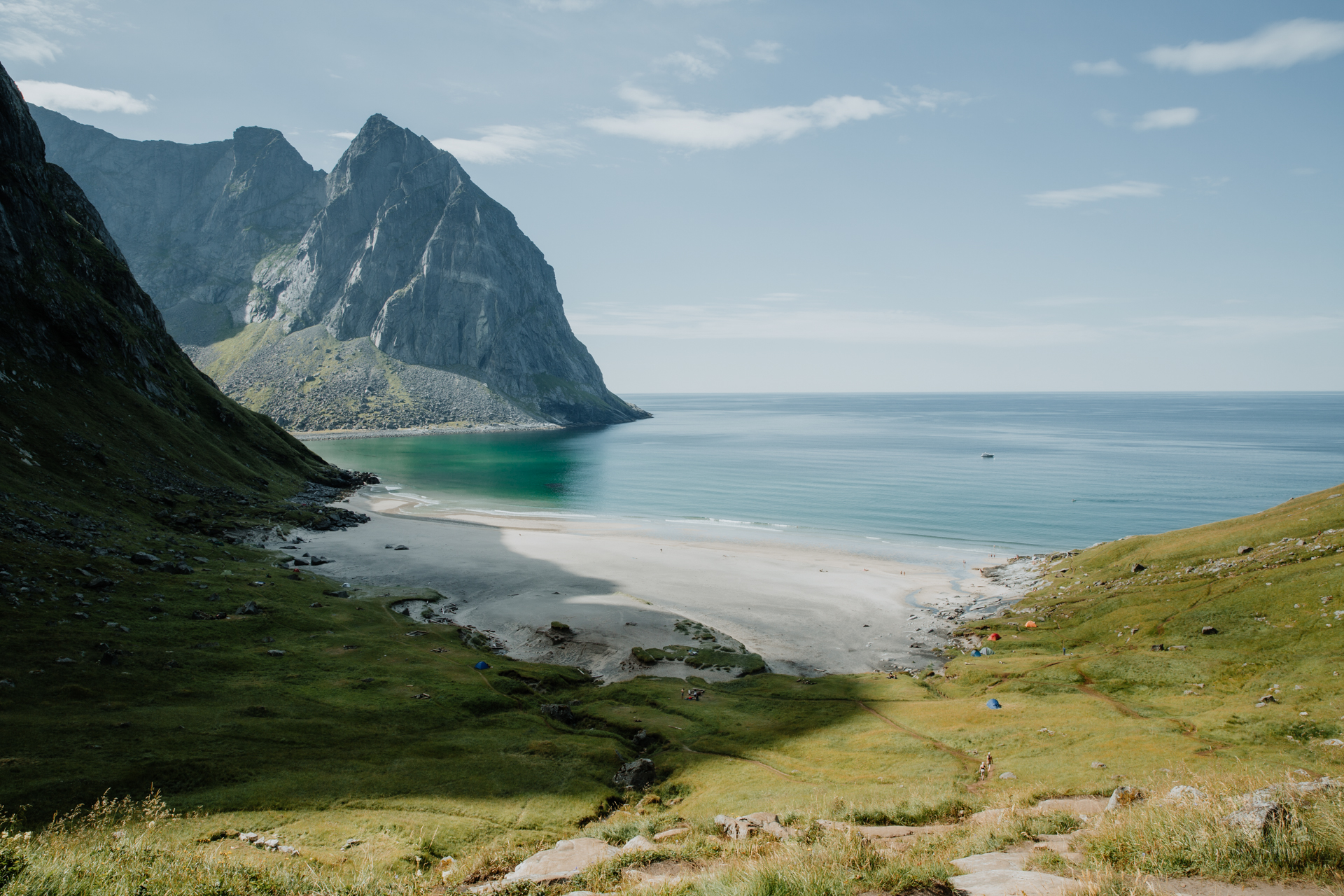
Today, Kvalvika Beach and Ryten mountain next to the beach are among the most popular hiking and camping destinations in Lofoten. On warm summer nights, the beach is crowded with tents and sleeping bags. In July 2020, I pitched my tent there too to gaze at the golden orange and red sunset once again. The beach had lost its isolated wilderness beach status, but the views were still epic.
If you are looking for a peaceful beach destination in Lofoten Islands, I recommend taking the amazing and quiet Horseid Beach hike!
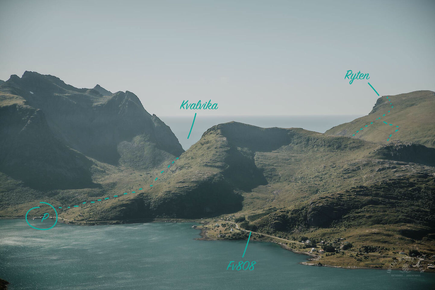
Kvalvika and Ryten - parking
There are three routes (two official) to Kvalvika and Ryten. The paths from the north and south are the longer ones, with the middle path between Torsfjordtinden and Molstinden being the shortest and easiest. The route on the south side is not marked on official maps, but there is a clear path through Lake Ågotvatnet.
The middle route to Kvalvika can be reached by car on the E10 to Fredvang. The E10 road turns onto the bridges at "Shark fin mountain" or Volandstinden, where there is a small parking spot (for 2-3 cars). After the bridges, turn left onto the Fv808, which leads directly to the sign for the Kvalvika trail.
There is a small free parking area on the left side of the road, which is probably full in the high season. Kvalvika gets a lot of day hikers, so a good strategy is to pull over and wait for someone to return to their car and make room for the next one. Parking spaces have been added in the direction of Sandbotnen. I didn't check these in 2020 because I managed to grap my spot at the free Kvalvika parking lot.
Here's the map for Kvalvika and Ryten hike and the free Kvalvika parking area (photo taken from Volandstinden):
Update summer 2025 (I've checked the parking areas in July 2025): two new large parking areas with information signs have been built on the Kvalvika and Ryten routes, also toilets can now be found in all parking areas. The car parks are subject to a fee, and can also be overcrowded during the high season. Parking outside the designated parking areas / outside the road may result in fine.
- The first alternative parking area is behind the Fredvang school, "Fredvang Parking", which also has a shuttle bus service to the Kvalvika path during the high season. The parking lot is located on the right side of the road just after the bridges.
- Another parking area can be found a short distance further along the Fv806, on the left side of the road. On Google Maps it is called "Ryten-Kvalvika".
- The third car park is at Innersand. Follow the Fv806 to the T-junction and turn left.


Kvalvika Beach hike
On the back of the free parking area there is also a pier for taking a refreshing swim. On the other side of the road next to the parking area there are a few stone steps and wooden planks that go across the small forestry area. Spot the "Kvalvika" sign, and head up to the hill.
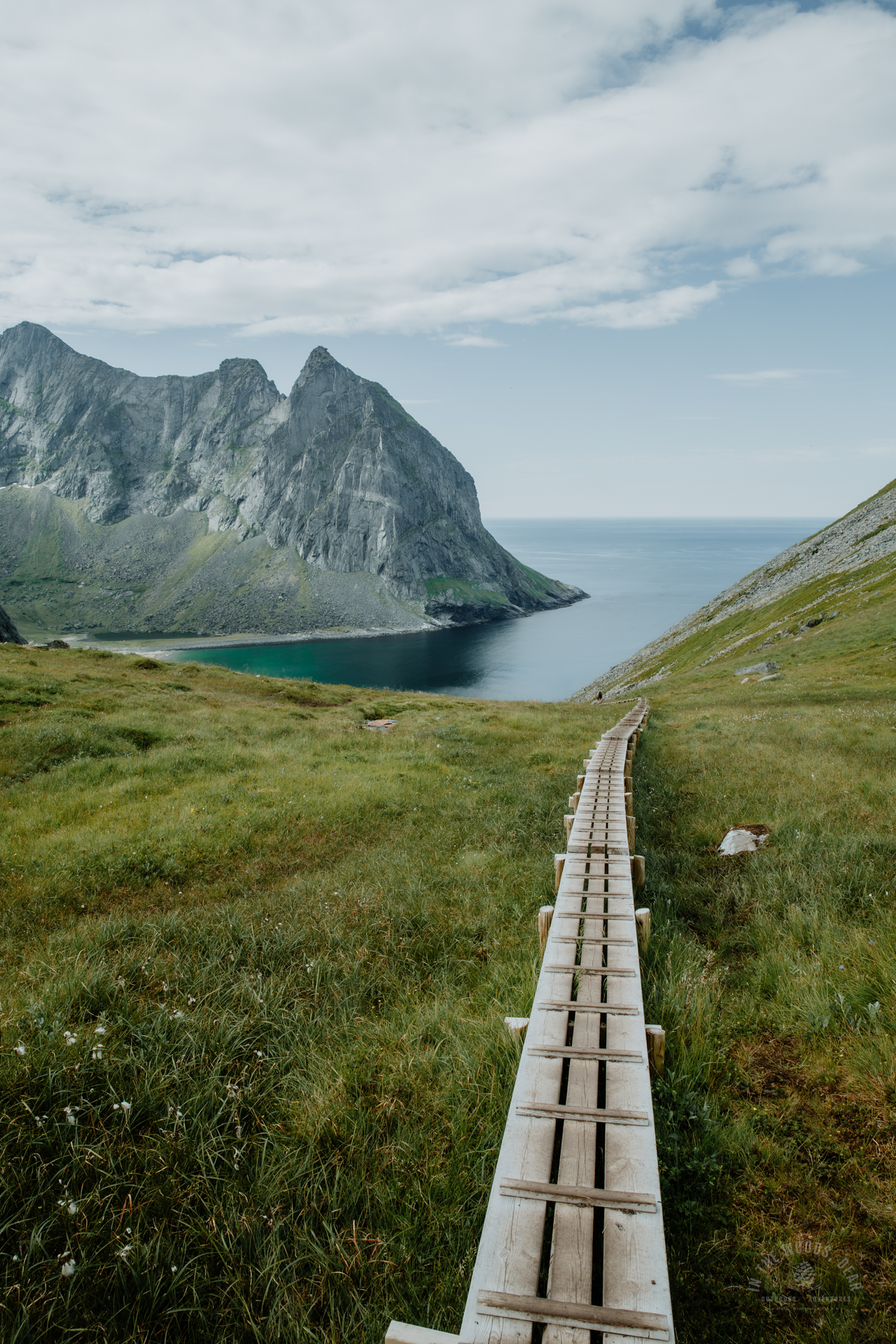
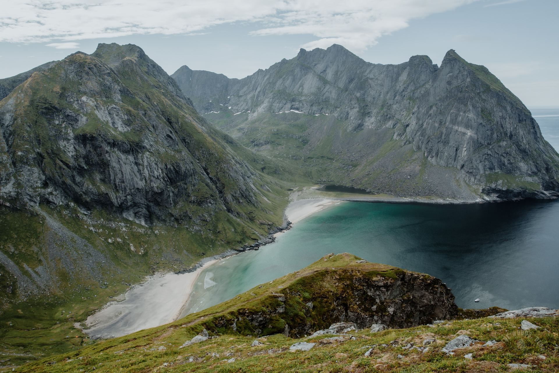
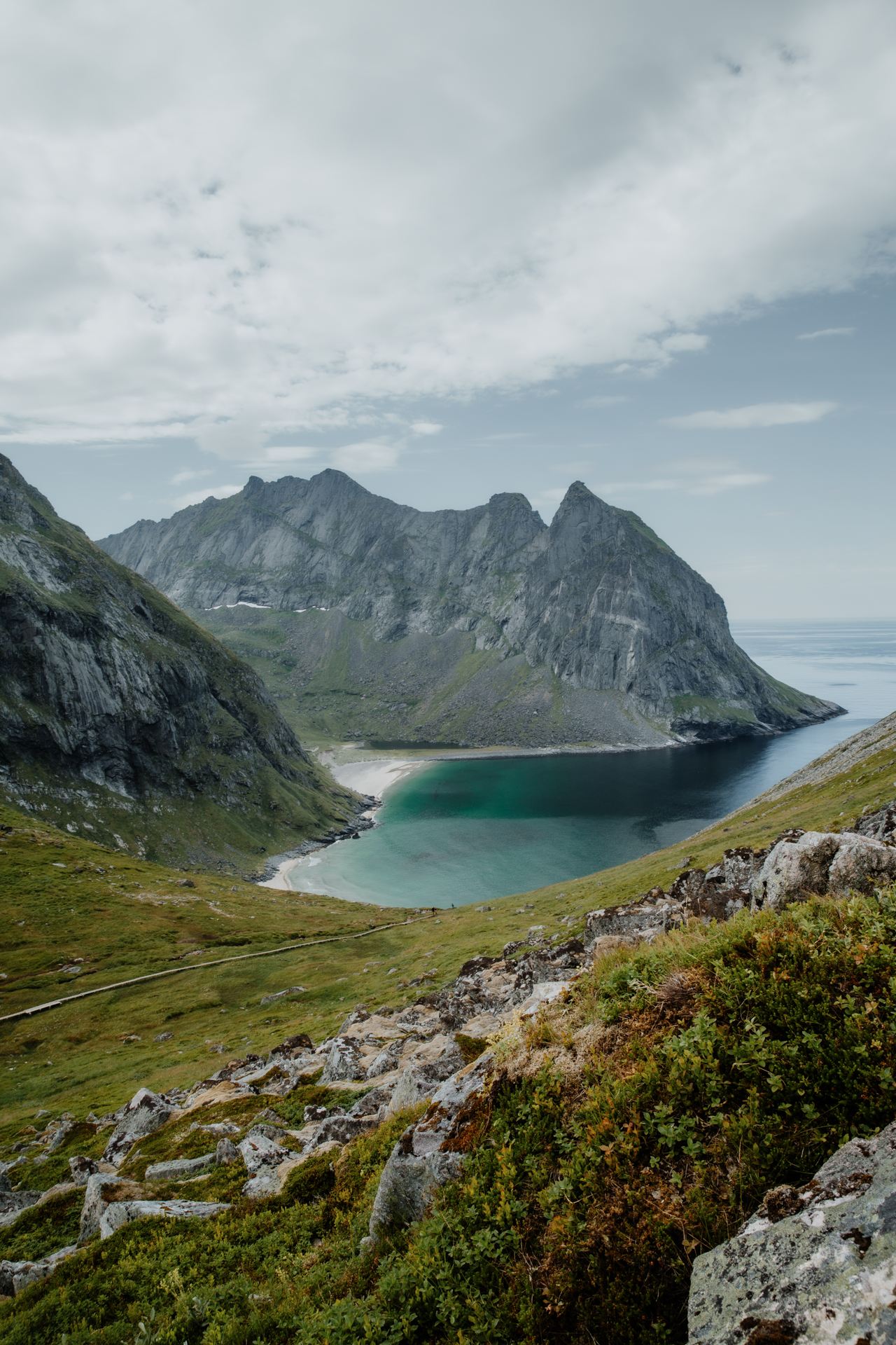
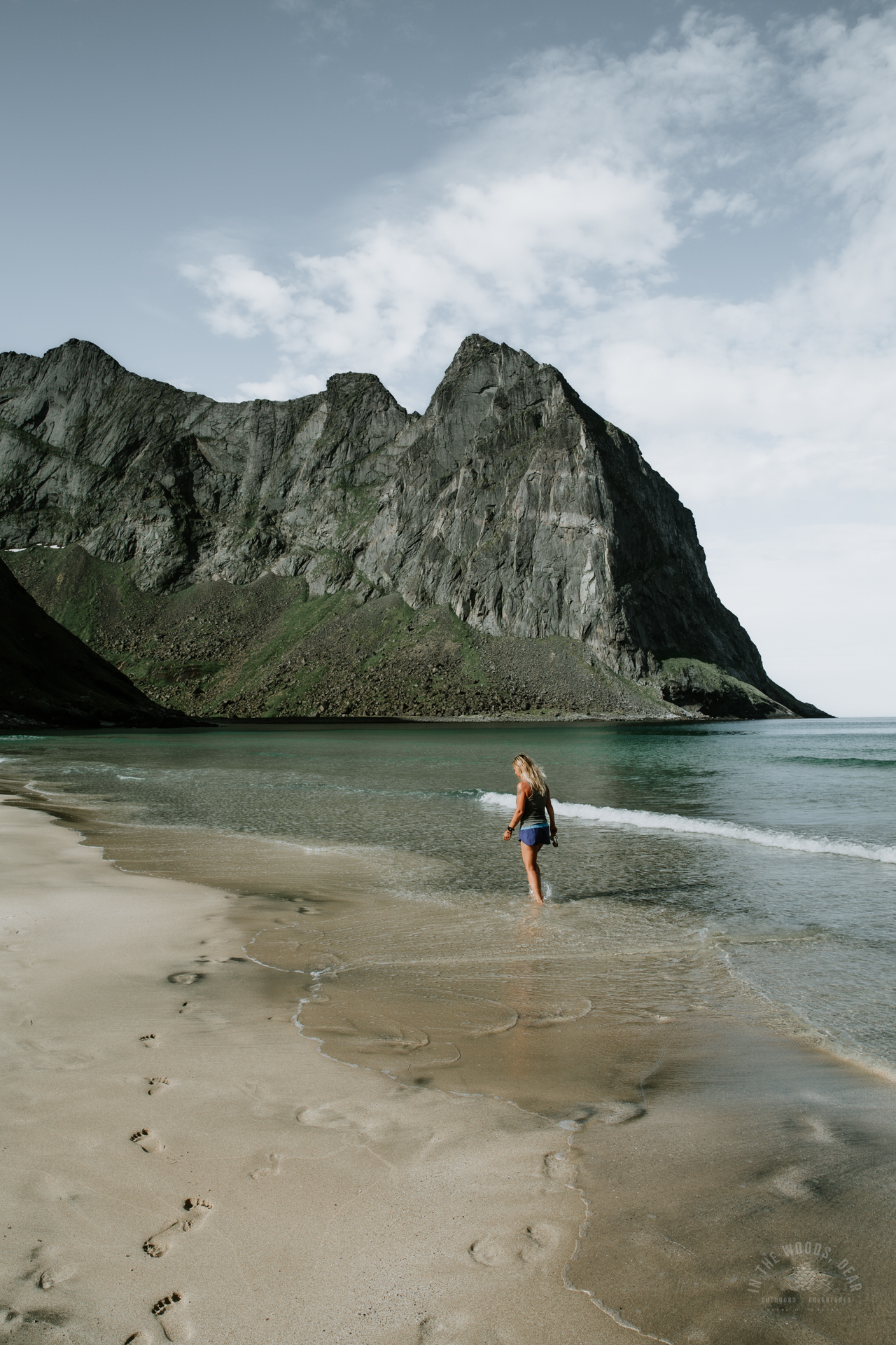
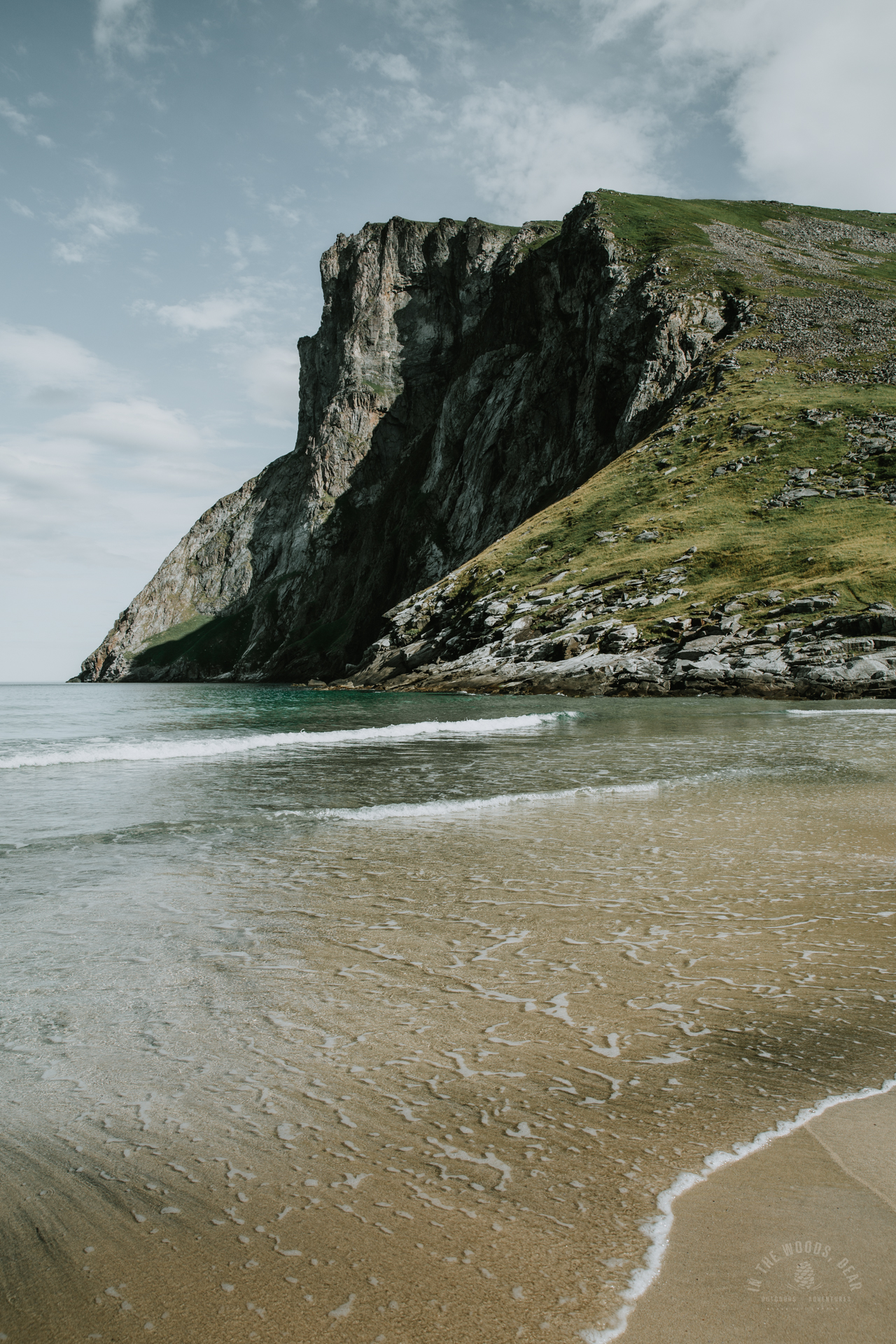
The first part of the trail is easy walking, not much elevation gain, and there’s a good path. After half an hour or so you already reach the highest point of the trail and get the first glimpses of the scenic views between two mountains. Then you'll see the beautiful Kvalvika Beach from above - the white sand, the turquoise water and green grass surrounded by majestic mountains.
The trail gets a bit more difficult, steep and rocky, which means some scrambling all the way descending down to the beach. There are several smaller paths going downwards, I chose one of the paths on the right side. The total hiking time is approximately one hour.
Camping by the Kvalvika beach
On the back of the wide sand strip there is a flat grass turf with several small pathways meandering between the tent spots. If you want a straight sea view from your tent, arrive early and pitch right on the edge of the turf. If you leave a two meters grass strip between your tent and the sunset, someone will squeeze their tipi there.
Alternatively, if you are certain it’s not going to rain, you can just throw your sleeping bag to the ground without any mosquito nets or rain covers. The ground is soft and even.
There are probably several campfires on Kvalvika Beach and sounds of a guitar or banjo in the air. You can set up your own fire using the driftwood or ask if you can join a ready-made fire. I sat on the ground in front of my tent with my stove and had Vegetarian Tikka Masala trekking meal as a late midnight dinner, some kind of ‘couscous’ that I flushed down with a pint of beer.
It’s not a long walk for carrying extra water, but there’s a fresh stream coming down from the mountains next to the trail to Ryten on the right side of the beach. There are nowadays also great toilet facilities on Kvalvika Beach: behind that big stone on the back of the beach (just follow the flies!).


Although the days in Lofoten Islands were ‘top and shorts’ hot, evenings got quite chilly. I had a cotton knit and light merino wool pants, and long wool socks (that I have knit myself :D). After midnight, I also needed a light down coat.
Walking slowly on the warm white sand, listening to the rhytmic sound of the waves crashing to the beach, and watching the spectacular sunset in fifty shades of red – that is the magic of Kvalvika Beach. I slept like a baby, and despite of the festival(ish) spirit, I felt nothing but inner peace and happiness.
Ryten (543 m) - Ryten hike
Maybe it was the long hours of hiking (I had hiked the long Munkebu hut hike before hiking to Kvalvika Beach), or maybe it was the cool ocean breeze, I had the laziest morning ever. I had planned to hike up to Ryten in the morning, but I had forgotten to bring a smaller day backpack to carry water, snacks and camera. I decided to go anyway, carrying my DSLR hanging from its strap and my iPhone in my hand (what’s the thing with women’s shorts having no big pockets?).
The trail starts from the right side of the beach near the water stream. The path is very steep and there’s also some scrambling up and down the large boulder hill. First, there are rocks and some stair-like stones with dust and gravel, until the trail turns muddy and wet. This part of the trail is the most challenging, as there are loose rocks and dirt. Having a heavy backpack could make it even a bit strenuous. Great morning exercise for the legs!
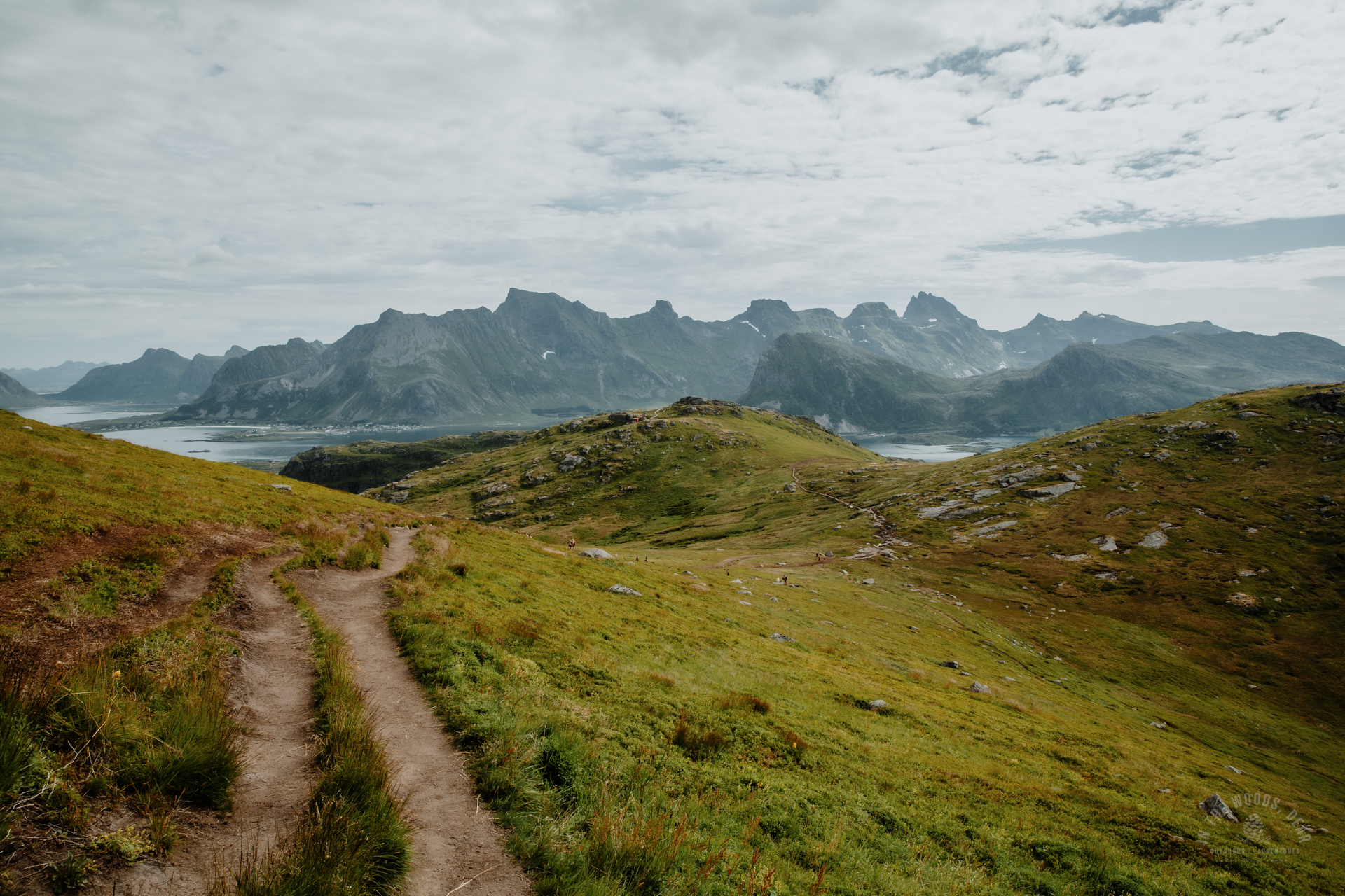
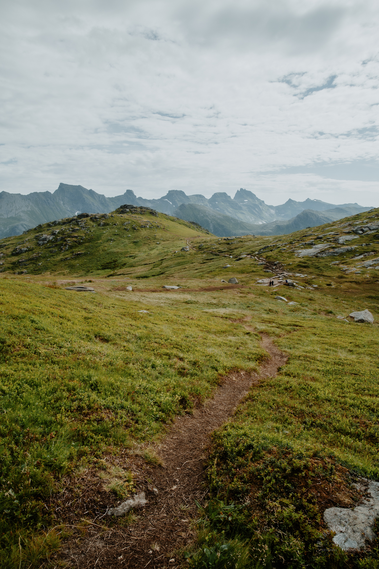
After a while, the trail reaches a saddle between mountains, and there’s a beautiful blue lake. Using the long wooden planks makes walking easier on the boggy plateau. Then you just turn left and up you go anytime you wish. There is probably one main trail coming from the right side but the mountain is full of smaller trails – as well as people heading to Ryten. A lot more people coming from the other direction compared to Kvalvika Beach.
Morning was turning to afternoon, and it was getting really warm. I was thirsty. I hiked to the first peak (South-East from the summit on the map) and sat down for a moment. The views were astonishing: the white sands, the turquoise water, and the dramatic mountains from the bird’s perspective. I took pictures and greeted a Finnish family who were having a picnic nearby.


Although the last part of the trail is easy walking, I decided it was not worth going any further. The summit was already extremely crowded and more people coming all the time, and I didn’t have either water or a tripod to take the ‘I was here’ pics. There’s a special spot at the summit of Ryten for taking pictures where you appear to hang dangerously from a cliff (there’s plenty of solid ground under that particular cliff). Well, I probably wouldn’t have taken that picture anyway.
As always, it was much faster to get down. I ran the runnable parts (with clumsy hiking boots) and drank water from the stream as soon as I reached the saddle’s end. On my way down I saw more and more people coming up, also a few people scrambling the slope with big backpacks continuing their journey from Kvalvika Beach to Ryten and forward. It's possible to hike a longer ring route visiting Kvalvika Beach and Ryten.
Swimming crossed my mind, but I just washed my feet on the beach walking in the water. Something that always amazes me in Norway: everything looks and feels like the warmest summer day ever, but when you go into the water, it’s like sticking your bones into ice. I really should consider getting back to ice swimming to build my stamina!
Late afternoon it was time to pack again and hike the trail back to the parking area in beautiful sunshine. If I’ll ever return to Kvalvika, I think I’ll do a winter road trip. To search for the out-of-this-world magic and solitude I experienced long time ago.
Lofotodden National Park
Kvalvika and Ryten are located in the Lofotodden National Park. The national park has strict rules for hiking in the area:
- Flying drones is strictly forbidden.
- Dogs must be kept on a leash from 1 April to 15 November.
- Cycling is prohibited on the path between Torsfjorden and Kvalvika.
- Camping is free, as long as you do not disturb the animals or damage the nature. A distance of at least 150 metres must be kept between the campsite and buildings.
- In Norway, it is forbidden to make campfires between 15 April and 15 November.
- All rubbish must be carried away from nature.


