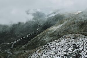
Solo Backpacking

Sarek National Park is located in Swedish Lapland, in Jokkmokk Municipality. The ruggedly beautiful Sarek is the oldest national park in Europe, and it is often called the last great wilderness of the North. Six out of thirteen peaks over 2,000 m are located within the boundaries of the national park, and there are around 100 glaciers.

Read more

Hiking in Sarek National Park

  • Destination: Jokkmokk Municipality, Lapland, Sweden
  • Distance: Around 72 km (From Suorva to Skierfe, without summits)
  • Difficulty: advanced / difficult (mountaineous wilderness), no marked trails, big river crossings, challenging weather 
  • When to go: from June to August for a summer hike  
  • Duration: multi-day adventure, a daytrip to Skierfe from Aktse
  • Where to stay: in a tent

Muotkatunturi wilderness in Northern Lapland is the most wilderness-like area in Finland. The wilderness area is located in Utsjoki and Inari counties. There are around a hundred fells in Muotkatunturi, but the scenery is very open with gentle slopes in the horizon.

Read more

Muotkatunturi wilderness area

  • Destination: Inari and Utsjoki, Lapland, Finland
  • Difficulty: advanced because of wilderness, includes river crossings
  • When to go: in September for an autumn hike 
  • Duration: suitable for day trips and multi-day adventures
  • Where to stay: camping in tent, two open wilderness huts, Lahtinen hut and a Lappish shelter for day shelters

Hiking in Beautiful Kevo Nature Reserve in Lapland

Kevo Strict Nature Reserve in Utsjoki is one of the most rugged hiking destinations in Lapland, Finland. In the heart of the nature reserve there's almost a 40 km Kevo canyon with River Kevojoki flowing in the middle. You can explore the beautiful nature reserve by hiking either Kuivi ring route or Kevo route.

Read more

Kevo Trail 63 km info

  • Destination: Utsjoki, Lapland, Finland
  • Distance: 63 km (one direction)
  • Difficulty: advanced, includes river crossings
  • When to go: in September for backpacking in autumn (check restrictions!)
  • Duration: 3-5 days
  • Where to stay: camping in tent, no open wilderness huts, some Lapp huts and turf huts for shelter

Kebnekaise Hike: Climbing Solo the Highest Peak in Sweden

Kebnekaise (Giebmegáisi in Sámi) is Sweden’s highest mountain, its summit reaching 2,097 m. It has two peaks, the southern Sydtoppen and the northern Nordtoppen. Kebnekaise is located in North Sweden around 80 kilometers from Kiruna. It’s a real Swedish classic hike in a high alpine environment.

Read more

Kebnekaise hike info

  • Destination: Norrbotten, Lapland, Sweden
  • Distance: 18 km (elevation gain 1,800 m) from Kebnekaise fell station
  • Difficulty: physically demanding but quite easy
  • When to go: from June to August for a summer hike
  • Duration: a daytrip, 10-14 hours
  • Where to stay: camping with or without facilities, or at Kebnekaise mountain lodge

Backpacking in Swedish Lapland: Vistas Valley

Vistas valley (Vistasdalen in Swedish, Vistasvagge in Sami) is a green oasis in high-alpine environment in Swedish Lappland near Kebnekaise. The trail runs between Nikkaluokta and Alesjaure along river Vistasjohka in the wide valley surrounded by mountains. The trail is well-marked all the way. You can also hike the 84 km trail from Nikkaluokta to Abisko through Vistas valley. There’s a mountain cabin, Vistastugan, in the middle of the valley providing facilities, such as accommodation for hikers. The river is popular for paddling trips as well. Sometimes you may spot Scandinavian elks wandering in the valley – I did!

Read more

Vistas valley hiking info

  • Destination: Vistas/Vistasdalen, Norrbotten, Lapland, Sweden
  • Distance: Alesjaure-Nikkaluokta 55 km (one direction)
  • Difficulty: easy-moderate, includes easy river/stream crossings
  • When to go: from July to August for a summer hike
  • Duration: 2-3 days
  • Where to stay: camping in tent, or Vistastugan mountain lodge

Halti is the highest fell in Finland with the peak, Háldičohkka, at 1324 m above the sea level. The trail to Halti from Kilpisjärvi, the Arctic Trail or Nordkalott Trail, is the most popular route to Halti from Finland, but several unmarked routes through wilderness lead to Halti as well. I chose the Nordkalott route on my way to Halti but hiked back to Kilpisjärvi via Termisjärvi, following the Arctic Trail to the Kuonjarjoki hut before taking my own path.

Read more

Kilpisjärvi - Halti hiking info

  • Destination: Kilpisjärvi and Käsivarsi Wilderness, Lapland, Finland
  • Distance: 55 km (one direction, The Nordkalott Trail)
  • Difficulty: advanced, includes river crossings
  • When to go: from July to September for a summer and autumn hike
  • Duration: 4-7 days
  • Where to stay: camping in tent, wilderness huts, or rental huts 

Hiking and Summitting Halti, Finland: a Solo Adventure

Halti is the highest fell in Finland with the peak, Háldičohkka, at 1324 m above the sea level. It can be summitted from Finland or from Norway as the fell is located at the border between two countries. The trail to Halti from Kilpisjärvi, the Arctic Trail (Nordkalott Trail), is the most popular route to Halti from Finland.

Read more

Kilpisjärvi - Halti hiking info

  • Destination: Kilpisjärvi and Käsivarsi Wilderness, Lapland, Finland
  • Distance: 55 km (one direction)
  • Difficulty: advanced, includes river crossings
  • When to go: from July to September for a summer and autumn hike
  • Duration: 4-7 days
  • Where to stay: camping in tent, wilderness huts, or rental huts 

Hiking, Backpacking and Trail Running Solo

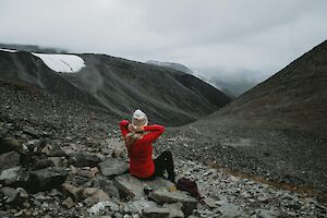
It’s usually recommended not to hike solo or go to the wilderness alone. But that doesn't mean you couldn't or shouldn't do it. I always run alone on the trails. I go hiking solo. And I go alone to the mountains and multi-day trekking journeys. Most of the time I don’t want to have company. I like the solitude and the silence, the freedom from distraction, being my own boss, and the boost to my self-esteem when I have managed difficult things all by myself. There are some outdoors sports that I wouldn’t do alone, such as kayaking, especially when going to the sea or for several days of kayak camping. But when I have solid ground under my feet, nothing could stop me from going for an adventure just by myself. It doesn’t matter whether I’m running alone in a forest for an hour or hiking two weeks – soloing has positive impacts on all areas of my life.

Read more


Galdhøpiggen hike: On the top of Scandinavia

Galdhøpiggen summit in Norway's Jotunheimen National Park is the highest point of Scandinavia and Northern Europe. To reach an astonishing panoramic view over the mountainous Norway, you just have to climb up to 2469 m.a.s.l. with around 1,500 meters of elevation gain.

Read more

Galdhøpiggen hike info

  • Destination: Jotunheimen National Park, Lom, Norway
  • Distance: 13 km (elevation gain 1,500 m) from Spiterstulen
  • Difficulty: physically demanding but quite easy
  • When to go: from June to August for a summer hike
  • Duration: a daytrip, 7-9 hours
  • Where to stay: camping with or without facilities, or at Spiterstulen Tourist Lodge

Hiking the 82 km Karhunkierros Bear's Trail 2/2

The most popular hiking trail in Finland is Karhunkierros, also known as the Bear’s Trail. It takes you through the Oulanka National Park to beautiful forests and scenic views by the swirling River Oulankajoki. The difficulty level varies from easy to more challenging, but I don’t think there are any difficult parts really, even if you are an unexperienced hiker.

Read more

Karhunkierros Bear’s Trail hike info

  • Destination: Oulanka National Park, Lapland and Northern Ostrobothnia, Finland
  • Distance: 82 km (several shorter distances available)
  • Difficulty: physically demanding but quite easy
  • When to go: from June to October for a summer and autumn hike
  • Duration: 3-5 days
  • Where to stay: camping in tent or wilderness huts for free, various camping sites and rental cottages and hotels in Ruka and Juuma